
On 12 Jul 1783 George Wilson surveyed 500 acres for Thomas Sanders that was located along the Cedar Creek that flows into Floyd's Fork. This was #18 on the 1811 plat drawing by James Shanks, Bullitt County Surveyor, which is described on another page. Sanders received a deed for this tract on 20 Sep 1786.
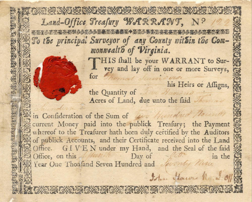
Warrant
Survey
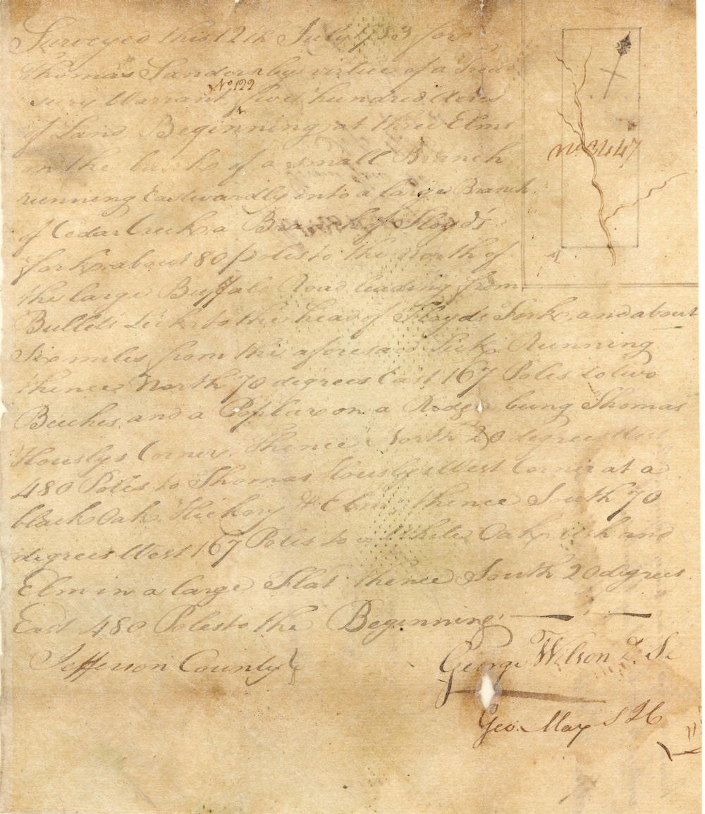
Surveyed this 12th July 1783 for Thomas Sanders by virtue of a treasury warrant No. 122, five hundred acres of land Beginning at 3 elms on the bank of a small branch running eastwardly into a large branch of Cedar Creek, a branch of Floyd's Fork about 80 poles to the north of the large Buffalo Road leading from Bullitt's Lick to the head of Floyd's Fork and about six miles from the aforesaid lick, running thence North 70° East 167 poles to two beeches and poplar on a ridge, being Thomas Housley's corner, thence North 20° West 480 poles to Thomas Housley's west corner at a black oak, hickory and elm, thence South 70° West 167 poles to white oak, ash & elm in a large flat, thence South 20° East 480 poles to the beginning. Jefferson County. George Wilson, surveyor.
Deed
Virginia Grant Book 8, pages 527-8
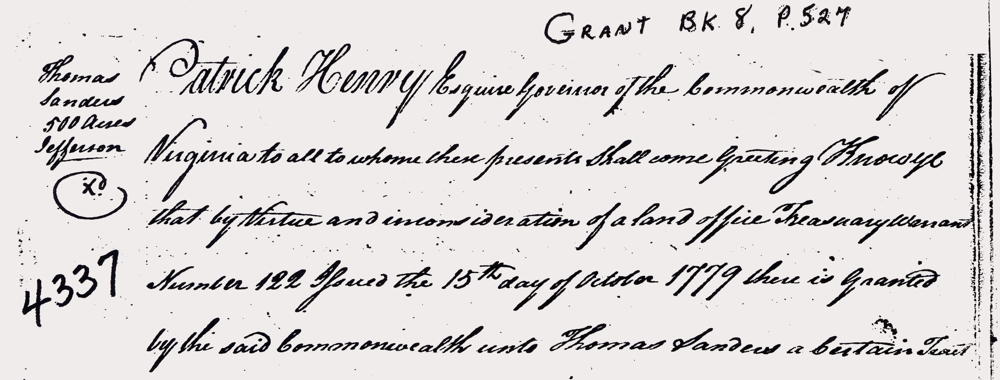
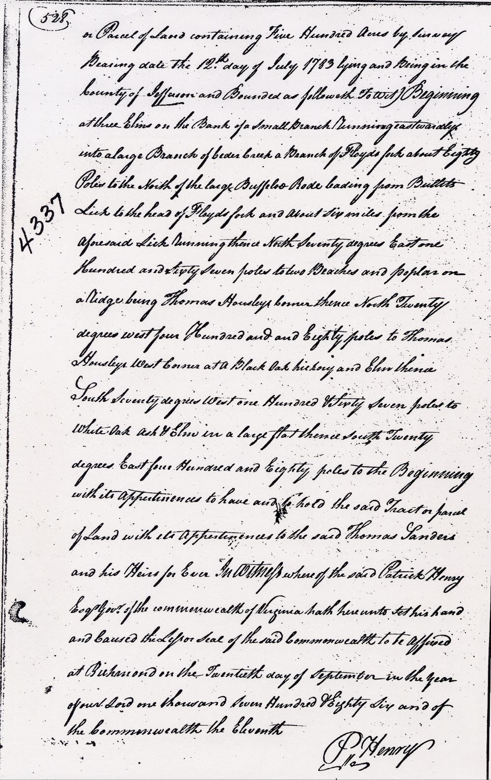
Patrick Henry Esquire, governor of the Commonwealth of Virginia, to all to whom these presents shall come, greeting. Know ye that by virtue and in consideration of a land office treasury warrant number 122 issued the 15th day of October 1779, there is granted by the said Commonwealth unto Thomas Sanders a certain tract or parcel of land containing 500 acres by survey bearing date the 12th day of July 1783, lying and being in the County of Jefferson and bounded as followeth, to wit. Beginning at 3 elms on the bank of a small branch running eastwardly into a large branch of Cedar Creek, a branch of Floyd's Fork about 80 poles to the north of the large Buffalo Road leading from Bullitt's Lick to the head of Floyd's Fork and about six miles from the aforesaid lick, running thence North 70° East 167 poles to two beeches and poplar on a ridge, being Thomas Housley's corner, thence North 20° West 480 poles to Thomas Housley's west corner at a black oak, hickory and elm, thence South 70° West 167 poles to white oak, ash & elm in a large flat, thence South 20° East 480 poles to the beginning with its appurtenances to have and to hold the said tract or parcel of land with its appurtenances to the said Thomas Sanders and his heirs forever. In witness whereof the said Patrick Henry Esquire, Governor of the Commonwealth of Virginia, hath hereunto set his hand and caused the lesser seal of the said Commonwealth to be affixed at Richmond on the 20th day of September in the year of our Lord 1786, and of the Commonwealth the 11th. (signed) P. Henry
If you, the reader, have an interest in any particular part of our county history, and wish to contribute to this effort, use the form on our Contact Us page to send us your comments about this, or any Bullitt County History page. We welcome your comments and suggestions. If you feel that we have misspoken at any point, please feel free to point this out to us.
The Bullitt County History Museum, a service of the Bullitt County Genealogical Society, is located in the county courthouse at 300 South Buckman Street (Highway 61) in Shepherdsville, Kentucky. The museum, along with its research room, is open 10 a.m. to 4 p.m. Monday through Friday. Saturday appointments are available by calling 502-921-0161 during our regular weekday hours. Admission is free. The museum, as part of the Bullitt County Genealogical Society, is a 501(c)3 tax exempt organization and is classified as a 509(a)2 public charity. Contributions and bequests are deductible under section 2055, 2106, or 2522 of the Internal Revenue Code. Page last modified: 21 Apr 2026 . Page URL: bullittcountyhistory.org/bchistory/4337-sanders.html