
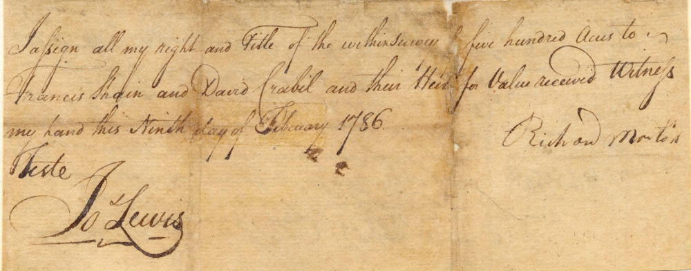
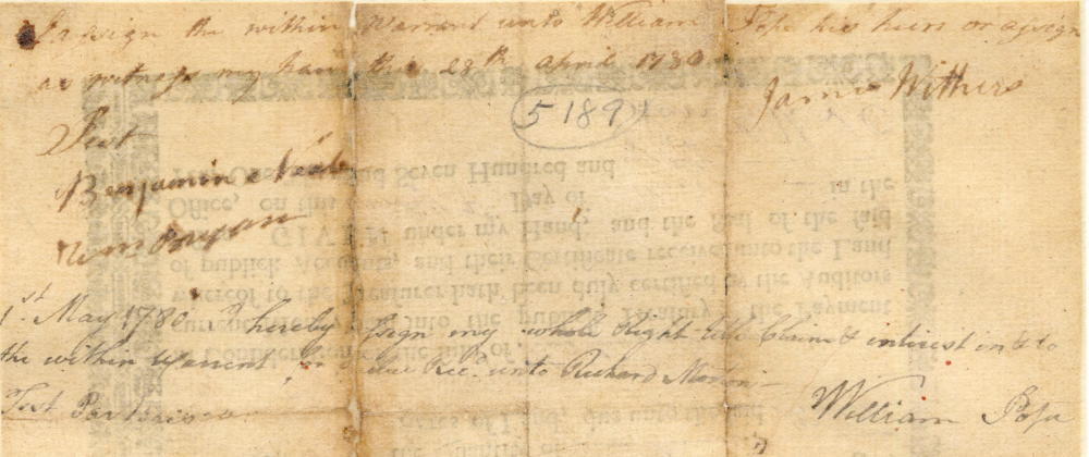
On 8 Feb 1786, Adam Shepherd surveyed 500 acres of land for Richard Morton along Crooked Creek in present-day Bullitt County. The next day, Morton endorsed the survey over to Francis Shain and David Crabil (Grable). Then Shain and Grable received a deed for the land on 21 Sep 1787.
Shain and Grable appear to have divided the tract with Grable taking the westwardly 200 acres, and Shain the remaining 300 acres.
As Bullitt County Sheriff, Grable used the 200 acres to support his bond to collect the county's revenue by signing it over to his bondsmen, William Caldwell, Samuel Simmons, William Morrow, Samuel Brown, Joseph Hedges, and Clifton Hall. They in return conveyed it back to him after he had cleared his indebtedness to them. Then in 1818, Grable sold his part to Isaac Collings.
Survey
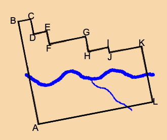
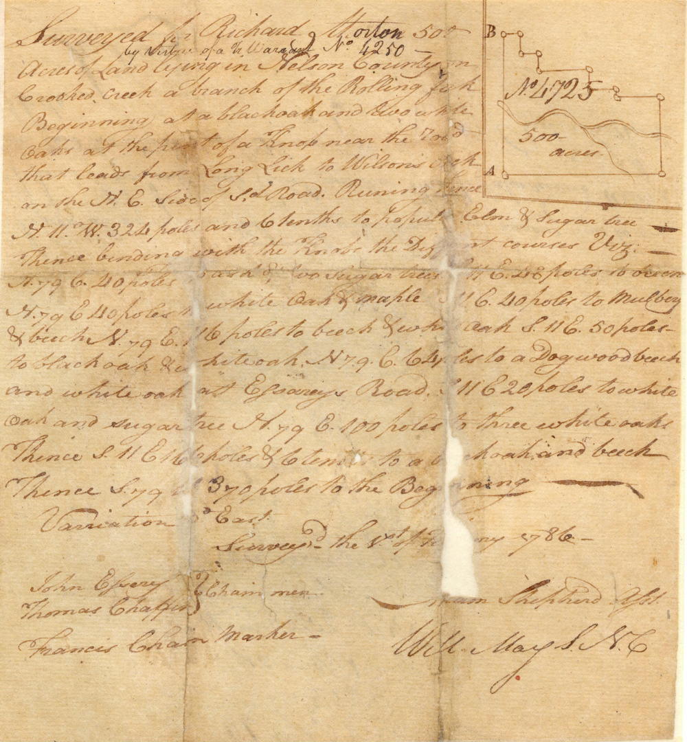
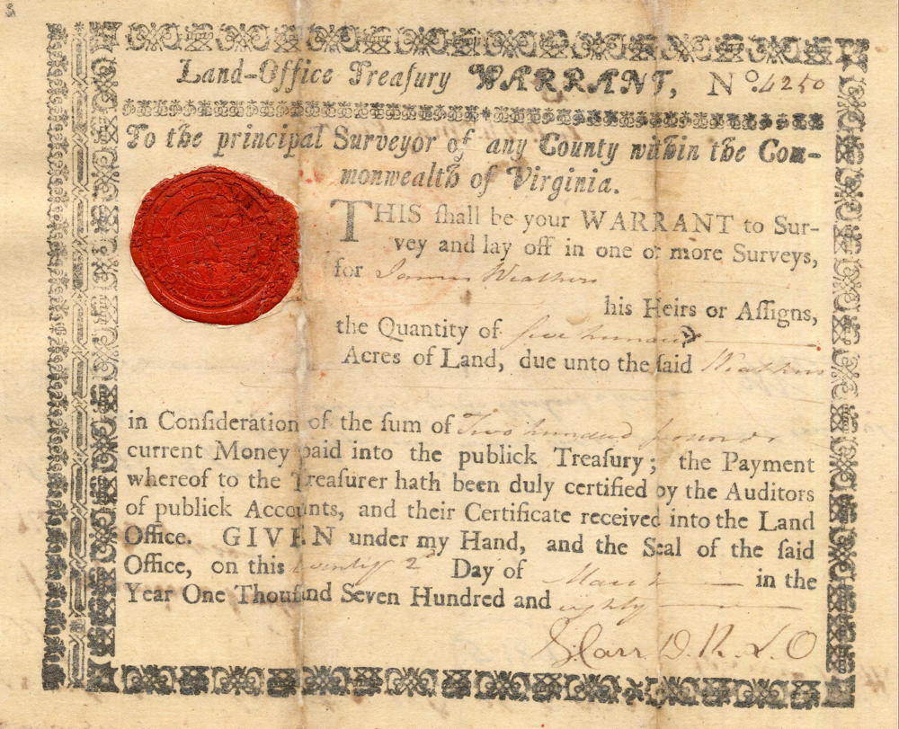
Surveyed for Richard Morton 500 acres of land by virtue of a treasury warrant number 4250 and lying in Nelson County on Crooked Creek, a branch of the Rolling Fork, beginning at [A] a black oak and two white oaks at the point of a knob near the road that leads from Long Lick to Wilson's lick and on the north east side of said road, running thence North 11° West 324 poles and 6/10 to [B] poplar, elm & sugar tree, thence binding with the knobs the different courses viz. North 79° East 40 poles to [C] an ash and two sugar trees, South 11° East 48 poles to [D] a beech, North 79° East 40 poles to [E] a white oak and maple, South 11° East 40 poles to [F] a mulberry and beech, North 79° East 116 poles to [G] a beach and white oak, South 11° East 50 poles to [H] a black oak and white oak, North 79° East 64 poles to [I] a dogwood, beech and white oak at Essarey's road, South 11° East 20 poles to [J] a white oak and sugar tree, North 79° East 100 poles to [K] three white oaks, thence South 11° East 166 poles and 6/10 to [L] a black oak and beech, thence South 79° West 370 poles to the beginning. Surveyed the 8th day of February 1786 by Adam Shepherd. John Essary & Thomas Chaffin, chain carriers; Francis Chain, marker.
Deed
Virginia Grant Book 14, pages 63-4
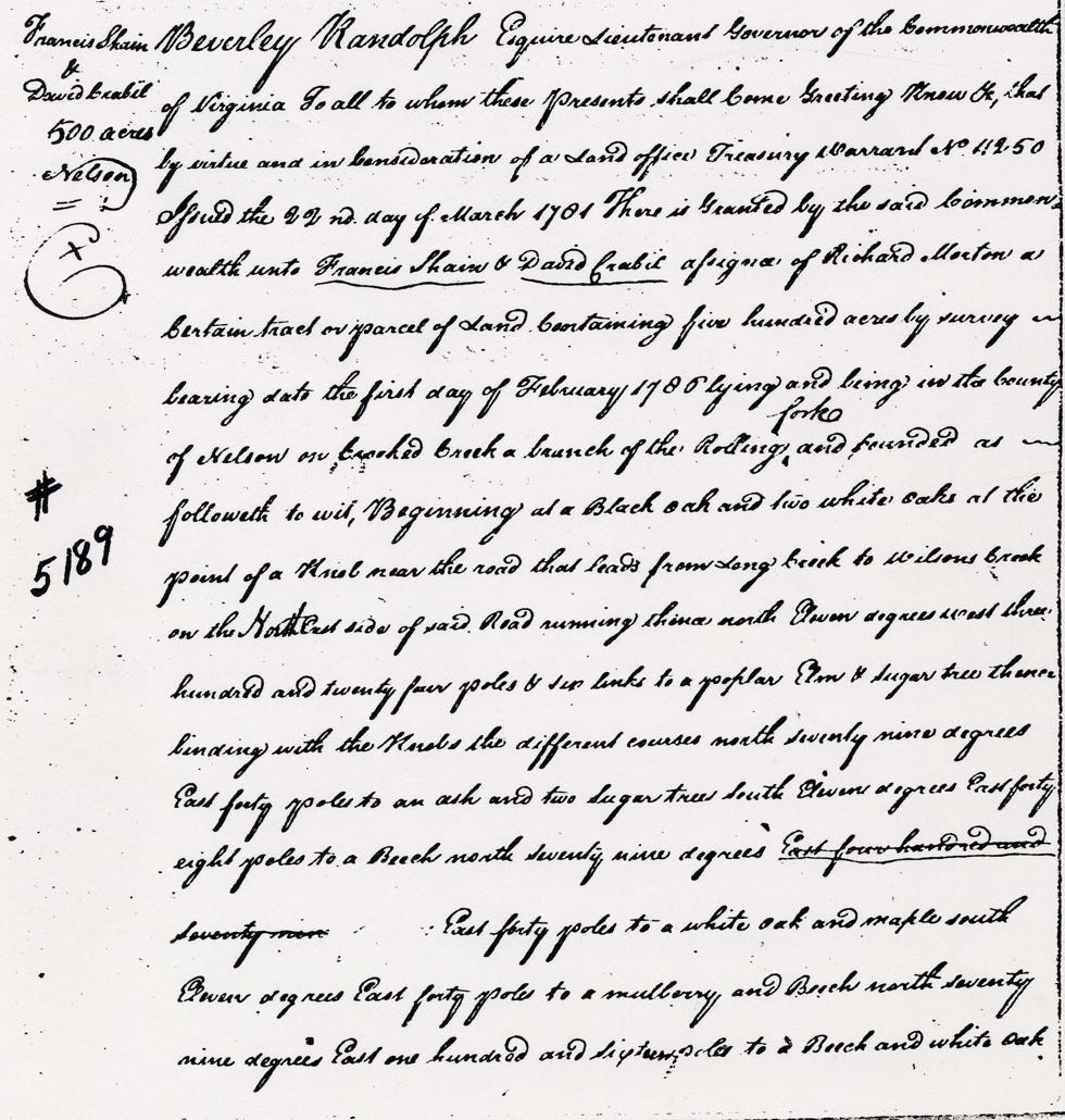
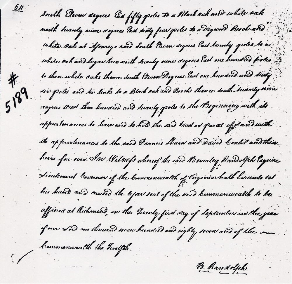
Beverly Randolph Esquire, Lieutenant Governor of the Commonwealth of Virginia, to all to whom these presents shall come, greeting. Know ye that by virtue and in consideration of part of a land office treasury warrant number 4250 issued the 22nd day of March 1781, there is granted by the said Commonwealth unto Francis Shain & David Crabil, assignees of Richard Morton, a certain tract or parcel of land containing 500 acres by survey bearing date the 1st day of February 1786, lying and being in the county of Nelson on Crooked Creek, a branch of the Rolling Fork, and bounded as followeth, to wit. Beginning at a black oak and two white oaks at the point of a knob near the road that leads from Long Lick to Wilson's lick and on the north east side of said road, running thence North 11° West 324 poles and 6/10 to poplar, elm & sugar tree, thence binding with the knobs the different courses viz. North 79° East 40 poles to an ash and two sugar trees, South 11° East 48 poles to a beech, North 79° East 40 poles to a white oak and maple, South 11° East 40 poles to a mulberry and beech, North 79° East 116 poles to a beach and white oak, South 11° East 50 poles to a black oak and white oak, North 79° East 64 poles to a dogwood, beech and white oak at Essarey's road, South 11° East 20 poles to a white oak and sugar tree, North 79° East 100 poles to three white oaks, thence South 11° East 166 poles and 6/10 to a black oak and beech, thence South 79° West 370 poles to the beginning with its appurtenances to have and to hold the said tract or parcel of land with its appurtenances to the said Francis Shain and David Crabil and their heirs forever. In witness whereof the said Beverly Randolph Esquire, Lieutenant Governor of the Commonwealth of Virginia hath hereunto set his hand and caused the lesser seal of the said Commonwealth to be affixed at Richmond on the 21st day of September in the year of our Lord 1787, and of the Commonwealth the 12th. (signed) B. Randolph
Warrant
If you, the reader, have an interest in any particular part of our county history, and wish to contribute to this effort, use the form on our Contact Us page to send us your comments about this, or any Bullitt County History page. We welcome your comments and suggestions. If you feel that we have misspoken at any point, please feel free to point this out to us.
The Bullitt County History Museum, a service of the Bullitt County Genealogical Society, is located in the county courthouse at 300 South Buckman Street (Highway 61) in Shepherdsville, Kentucky. The museum, along with its research room, is open 10 a.m. to 4 p.m. Monday through Friday. Saturday appointments are available by calling 502-921-0161 during our regular weekday hours. Admission is free. The museum, as part of the Bullitt County Genealogical Society, is a 501(c)3 tax exempt organization and is classified as a 509(a)2 public charity. Contributions and bequests are deductible under section 2055, 2106, or 2522 of the Internal Revenue Code. Page last modified: 21 Apr 2026 . Page URL: bullittcountyhistory.org/bchistory/5189-shain.html