
On James Shanks' 1811 Plat Drawing, he identified three tracts [#1, #2, & #3] then belonging to Joseph Brooks, and indicated that Brooks was an assignee of Holden who was an assignee of Beasley. The Holden listed was actually John Holder, and the Beasley was named Major Beasley which appears to be his actual name, and not just a title.
Below we have identified these original plats, and attempted to document how they went from Beasley to Holder. It is not yet clear how the tracts ended up in the hands of Samuel Price, but he sold them to Joseph Brooks in 1791.
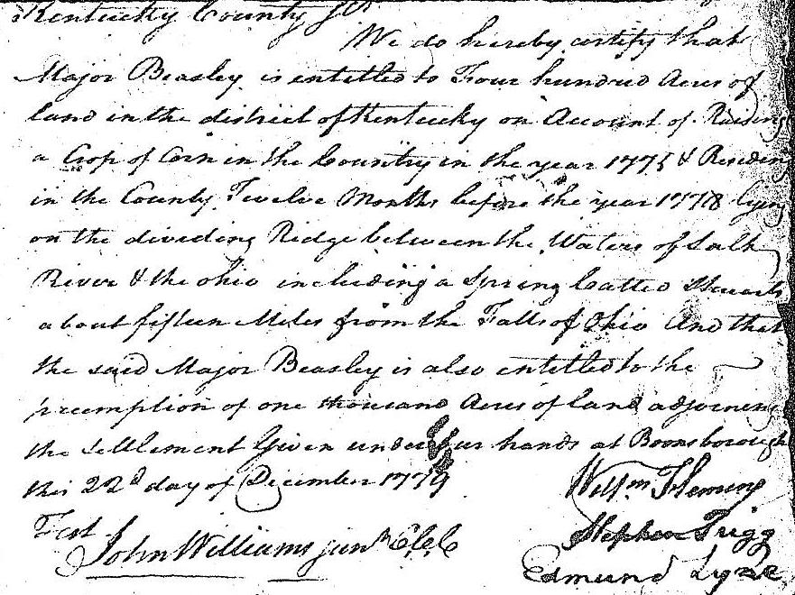
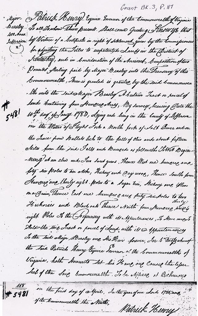
On 22 Dec 1779, Major Beasley was granted a settlement of 400 acres, and the preemption of 1000 more according to the document shown below.
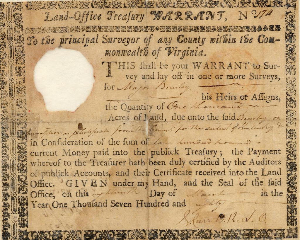
The following March, 1780, he paid 400 pounds to obtain a Virginia Treasury Warrant to cover the 1000 acre preemption.
Then on 10 Jan 1883, Will Oldham and George May surveyed the 400 acre settlement, with two 500 acre preemptions to the east and west of it.
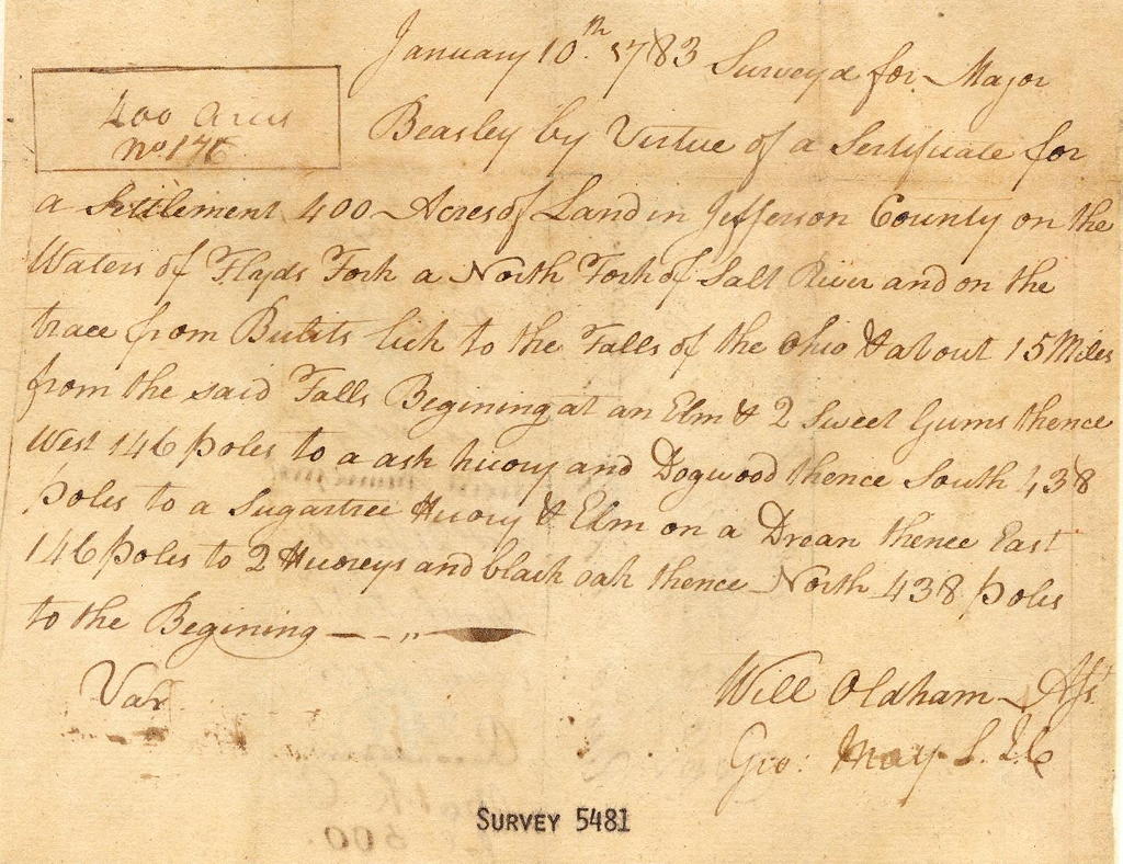
Surveyed for Major Beasley by virtue of a certificate for a settlement 400 acres of land in Jefferson County on the waters of Floyd's Fork, a North Fork of Salt River, and on the trace from Bullitt's Lick to the Falls of the Ohio & about 15 miles from the said Falls. Beginning at an Elm & 2 Sweet Gums, thence West 146 poles to an Ash, Hickory, and Dogwood, thence South 438 poles to a Sugartree, Hickory & Elm on a Drean, thence East 146 poles to 2 Hickories and Black Oak, thence North 438 poles to the beginning.
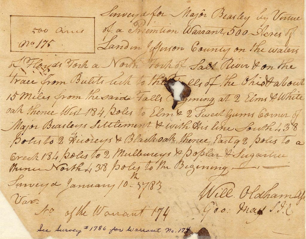
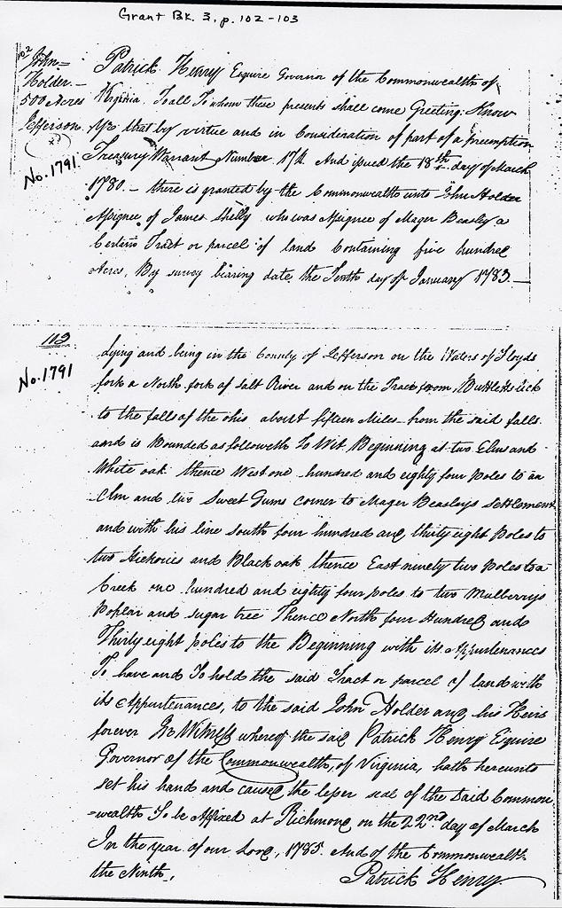
Surveyed for Major Beasley by virtue of a preemption warrant, 500 acres of land in Jefferson County on the waters of Floyd's Fork, a North Fork of Salt River, & on the trace from Bullitt's Lick to the Falls of the Ohio, & about 15 miles from the said Falls. Beginning at 2 Elms & White Oak, thence West 184 poles to Elm and 2 Sweet Gums, corner of Major Beasley's settlement, & and with his line South 438 poles to 2 Hickories & Black Oak, thence East, 92 poles to a creek, 184 poles to 2 Mulberrys , a poplar, & Sugartree, thence North 438 poles to the beginning.
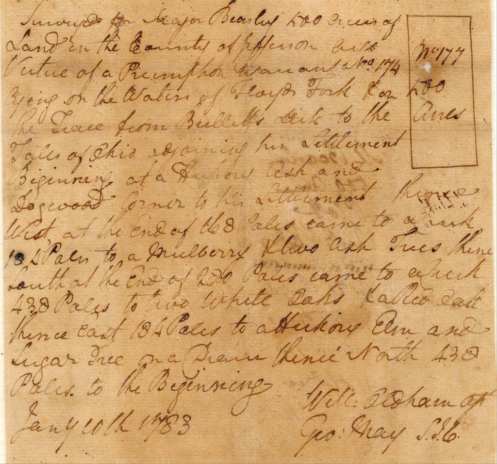
Surveyed for Major Beasley 500 acres of land in the County of Jefferson by virtue of a preemption warrant No. 174, lying on the waters of Floyd's Fork & on the trace from Bullitt's Lick to the Falls of Ohio, adjoining his settlement. Beginning at a Hickory, Ash, and Dogwood, corner to his settlement, thence West, at the end of 168 poles came to a creek, 184 poles to a Mulberry & two Ash trees, thence South, at the end of 280 poles came to a creek, 438 poles to two White Oaks & a Red Oak, thence East 184 poles to a Hickory, Elm and Sugartree on a Drein, thence North 438 poles to the beginning.
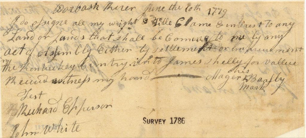
However, it appears that Beasley had already transfered ownership of this land to James Shelly in June 1779.
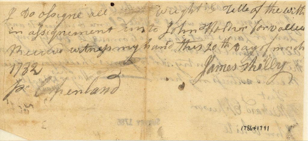
Then in March 1782, Shelly transfered it to John Holder.
Deeds to the three tracts were finally issued in March and April 1785, as shown below. The first tract, deeded on 22 Mar 1785 to John Holder, was the 500 acre tract to the west of the settlement tract.
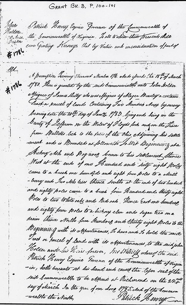
The second tract, also deeded on 22 Mar 1785 to John Holder, was the 500 acre tract to the east of the settlement tract.
It is interesting to note that the settlement tract was deeded to Major Beasley on 1 Apr 1785. This may have been a formality, since Beasley had already passed ownership to Holder, by way of Shelly.
If you, the reader, have an interest in any particular part of our county history, and wish to contribute to this effort, use the form on our Contact Us page to send us your comments about this, or any Bullitt County History page. We welcome your comments and suggestions. If you feel that we have misspoken at any point, please feel free to point this out to us.
The Bullitt County History Museum, a service of the Bullitt County Genealogical Society, is located in the county courthouse at 300 South Buckman Street (Highway 61) in Shepherdsville, Kentucky. The museum, along with its research room, is open 10 a.m. to 4 p.m. Monday through Friday. Saturday appointments are available by calling 502-921-0161 during our regular weekday hours. Admission is free. The museum, as part of the Bullitt County Genealogical Society, is a 501(c)3 tax exempt organization and is classified as a 509(a)2 public charity. Contributions and bequests are deductible under section 2055, 2106, or 2522 of the Internal Revenue Code. Page last modified: 12 Apr 2026 . Page URL: bullittcountyhistory.org/bchistory/beasley-plats.html