
John Ray surveyed a 500 acre tract for Benjamin Edwards on 2 Apr 1789 "about one mile southwestwardly from Salt River ferry." A deed to the tract was issued on 20 Mar 1793. Both survey and deed are shown below, together with their transcriptions.
Survey
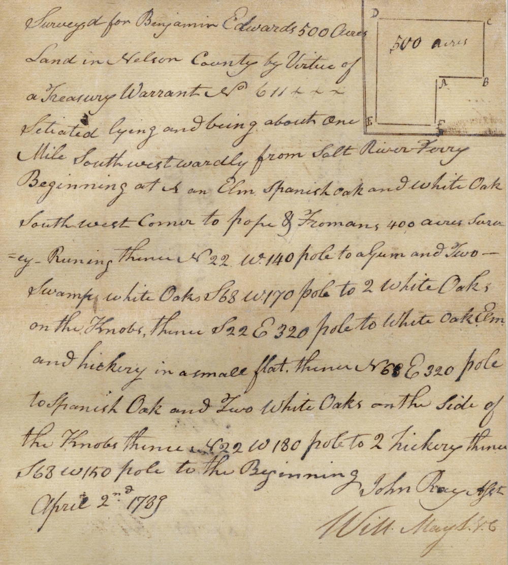
Surveyed for Benjamin Edwards 500 acres land in Nelson County by virtue of a treasury warrant No. 611 situated lying and being about one mile southwestwardly from Salt River ferry, Beginning at an elm, Spanish oak and white oak, southwest corner to Pope & Froman's 400 acres survey, running thence N 22 W 140 poles to a gum and two swamp white oaks, S 68 W 170 poles to 2 white oaks on the knobs, thence S 22 E 320 poles to white oak, elm, and hickory in a small flat, thence N 68 E 320 poles to Spanish oak and two white oaks on the side of the knobs, thence N 22 W 180 poles to 2 hickory, thence S 68 W 150 poles to the Beginning. April 2nd 1789. John Ray, Assistant Surveyor
Deed
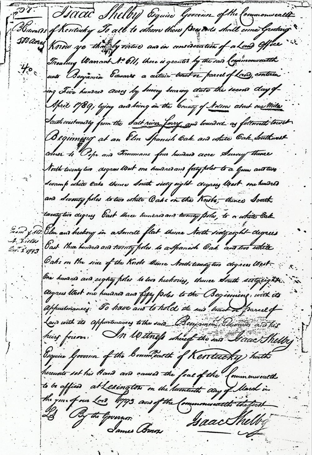
Isaac Shelby Esquire, Governor of the Commonwealth of Kentucky, to all to whom these presents shall come, greeting. Know ye that by virtue and in consideration of a land office treasury warrant No. 611, there is granted by the said Commonwealth unto Benjamin Edwards a certain tract or parcel of land containing five hundred acres by survey bearing date the second day of April 1789, lying and being in the county of Nelson about one mile southwestwardly from the Salt River ferry and bounded as followeth to wit. Beginning at an elm, Spanish oak and white oak, southwest corner to Pope and Froman's four hundred acre survey, thence North twenty two degrees West one hundred and forty poles to a gum and two swamp white oaks, thence South sixty eight degrees West one hundredd and seventy poles to two white oaks on the knobs, thence South twenty two degrees East, three hundred and twenty poles to a white oak, elm and hickory in a small flat, thence North sixty eight degrees East three hundred and twenty poles to a Spanish oak and two white oaks on he side of the knobs, thence North twenty two degrees West one hundred and eighty poles to two hickories, thence South sixty eight degrees West one hundred and fifty poles to the beginning with its appurtenances to have and to hold the said tract or parcel of land with its appurtenances to the said Benjamin Edwards and his heirs forever. In witness whereof the said Isaac Shelby Esquire, Governor of the Commonwealth of Kentucky, hath hereunto set his hand and caused the seal of the Commonwealth to be affixed at Lexington on the twentieth day of March in the year of our Lord 1793 and of the Commonwealth the first. (signed) Isaac Shelby
If you, the reader, have an interest in any particular part of our county history, and wish to contribute to this effort, use the form on our Contact Us page to send us your comments about this, or any Bullitt County History page. We welcome your comments and suggestions. If you feel that we have misspoken at any point, please feel free to point this out to us.
The Bullitt County History Museum, a service of the Bullitt County Genealogical Society, is located in the county courthouse at 300 South Buckman Street (Highway 61) in Shepherdsville, Kentucky. The museum, along with its research room, is open 10 a.m. to 4 p.m. Monday through Friday. Saturday appointments are available by calling 502-921-0161 during our regular weekday hours. Admission is free. The museum, as part of the Bullitt County Genealogical Society, is a 501(c)3 tax exempt organization and is classified as a 509(a)2 public charity. Contributions and bequests are deductible under section 2055, 2106, or 2522 of the Internal Revenue Code. Page last modified: 12 Apr 2026 . Page URL: bullittcountyhistory.org/bchistory/benjamin-edwards500.html