
Isaac Cox surveyed 1500 acres south of Salt River and near Rolling Fork for Jacob Myers on 1 Dec 1784. Myers obtained a deed for it on 14 Aug 1786. The survey and deed, and their transcriptions are below.
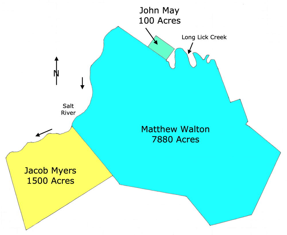
This drawing shows the relationship of this tract with that of two other tracts, that of Matthew Walton's 7880 acre tract, and John May's 100 acre tract. The lengths of the straight boundary lines are close to correct; the waterway boundaries are mostly guesswork.
Survey
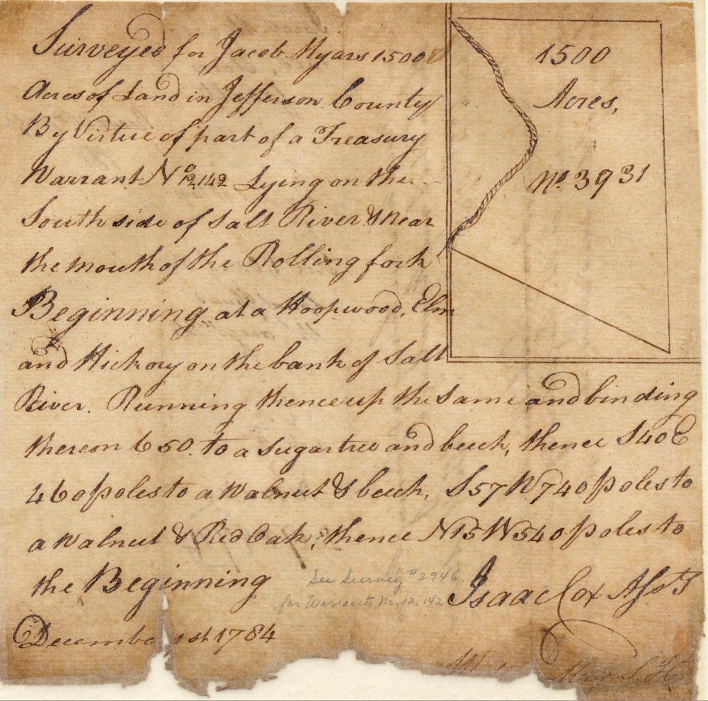
Surveyed for Jacob Myers 1500 acres of land in Jefferson County by virtue of part of a treasury warrant No. 12142 lying on the south side of Salt River & near the mouth of the Rolling Fork. Beginning at a hoopwood, elm and hickory on the bank of Salt River, running thence up the same and binding thereon 650 [poles] to a sugar tree and beech, thence S 40 E 460 poles to a walnut & beech, S 57 W 740 poles to a walnut & red oak, thence N 15 W 540 poles to the beginning. December 1st 1784. Isaac Cox, assistant surveyor
Deed
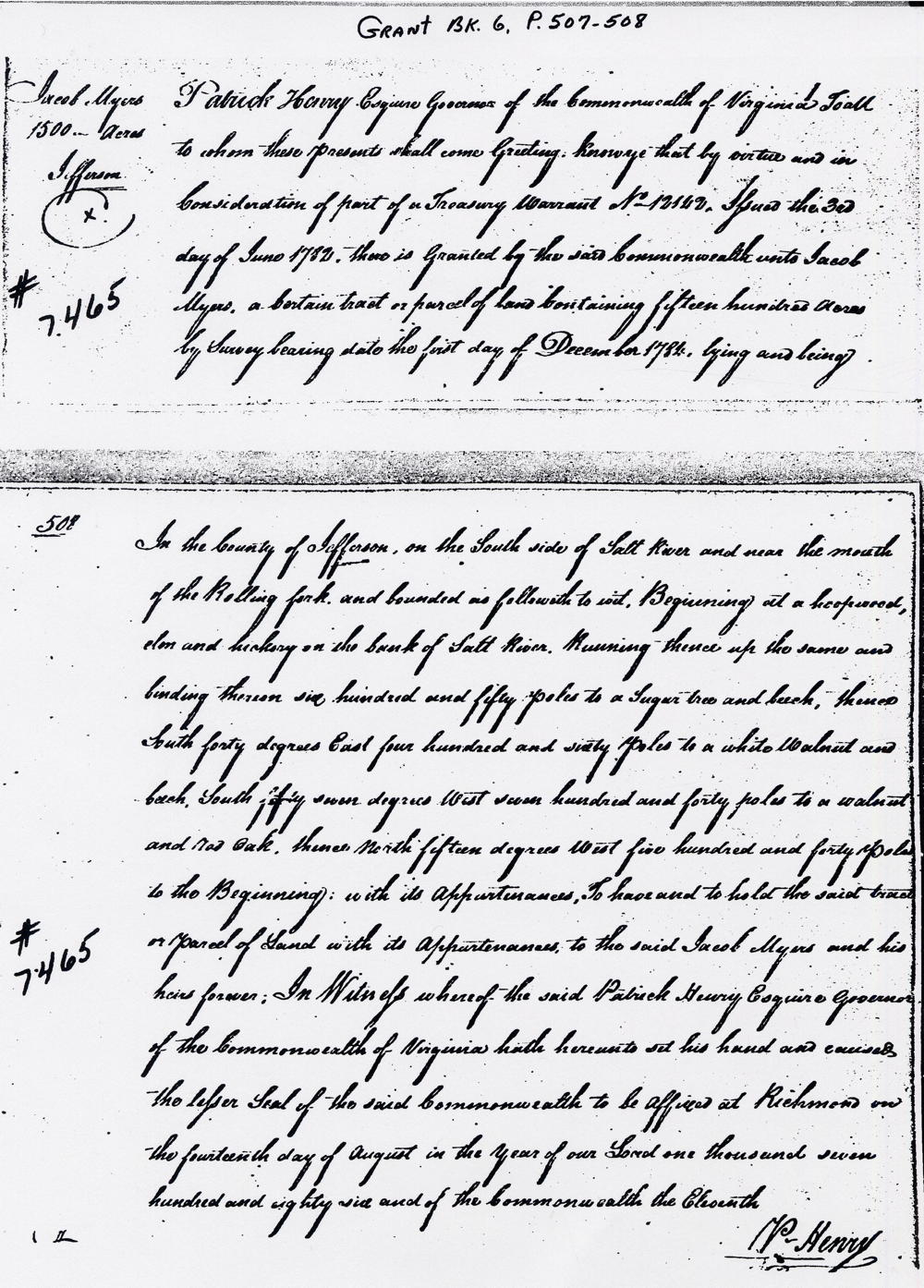
Virginia Grant Book 6, pages 507-508
Patrick Henry Esquire, Governor of the Commonwealth of Virginia, to all to whom these presents shall come, greeting. Know ye that by virtue and in consideration of a treasury warrant No. 12142 issued the 3rd day of June 1782 there is granted by the said Commonwealth unto Jacob Myers a certain tract or parcel of land containing fifteen hundred acres by survey bearing date the first day of December 1784, lying and being in the county of Jefferson on the south side of Salt River and near the mouth of the Rolling Fork and bounded as followeth to wit. Beginning at a hoopwood, elm and hickory on the bank of Salt River, running thence up the same and binding thereon six hundred and fifty poles t oa sugar tree and beech, thence South forty degrees East four hundred and sixty poles to a white walnut and beech, South fifty seven degrees West seven hundred and forty poles to a walnut and red oak, thence North fifteen degrees West five hundred and forty poles to the beginning with its appurtenances to have and to hold the said tract or parcel of land with its appurtenances to the said Jacob Myers and his heirs forever. In witness whereof the said Patrick Henry Esquire, Governor of the Commonwealth of Virginia, hath hereunto set his hand and caused the lesser seal of the said Commonwealth to be affixed at Richmond on the fourteenth day of August in the year of our Lord one thousand seven hundred and eighty six, and of the Commonwealth the eleventh. (signed) P. Henry
If you, the reader, have an interest in any particular part of our county history, and wish to contribute to this effort, use the form on our Contact Us page to send us your comments about this, or any Bullitt County History page. We welcome your comments and suggestions. If you feel that we have misspoken at any point, please feel free to point this out to us.
The Bullitt County History Museum, a service of the Bullitt County Genealogical Society, is located in the county courthouse at 300 South Buckman Street (Highway 61) in Shepherdsville, Kentucky. The museum, along with its research room, is open 10 a.m. to 4 p.m. Monday through Friday. Saturday appointments are available by calling 502-921-0161 during our regular weekday hours. Admission is free. The museum, as part of the Bullitt County Genealogical Society, is a 501(c)3 tax exempt organization and is classified as a 509(a)2 public charity. Contributions and bequests are deductible under section 2055, 2106, or 2522 of the Internal Revenue Code. Page last modified: 12 Sep 2024 . Page URL: bullittcountyhistory.org/bchistory/jacob-myers7465.html