
According to the Virginia Land Commission, Henry Tillen was in Kentucky in 1775, and was entitled to a 400 acre settlement "on the south side of Salt River extending from the first great crossing above Bullitt's Lick to his cabbin along the buffalo path." He was also entitled to an adjoining 1000 acre preemption if he could pay for it. Here is the certificate and its transcription.
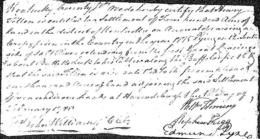
Kentucky County Sct.
We do hereby certify that Henry Tillen is entitled to a settlement of four hundred acres of land in the district of Kentucky on account of raising a crop of corn in the country in the year 1775, lying on the south side of Salt River extending from the first great crossing above Bullitt's Lick to his cabbin along the buffalo path & that the said Tillen is also entitled to the preemption of one thousand acres of land adjoining the said settlement. Given under our hands at Harrodsburgh this 18th day of February 1780. (signed) William Fleming, Stephen Trigg, Edmund Lynes (commissioners)
However, Tillen almost immediately signed his right to this settlement and preemption to Jacob Myers, as shown below.
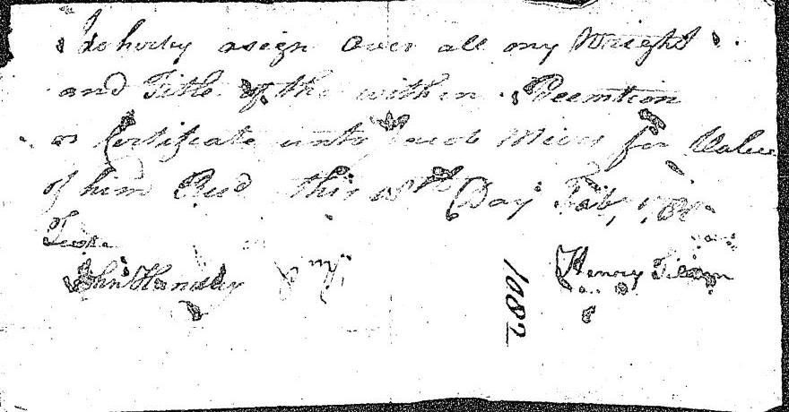
I do hereby assign over all my wright and title of the within preemption or certificate unto Jacob Meirs for value of him rec'd this 18th day Feb. 1780. (signed) Henry Tillen
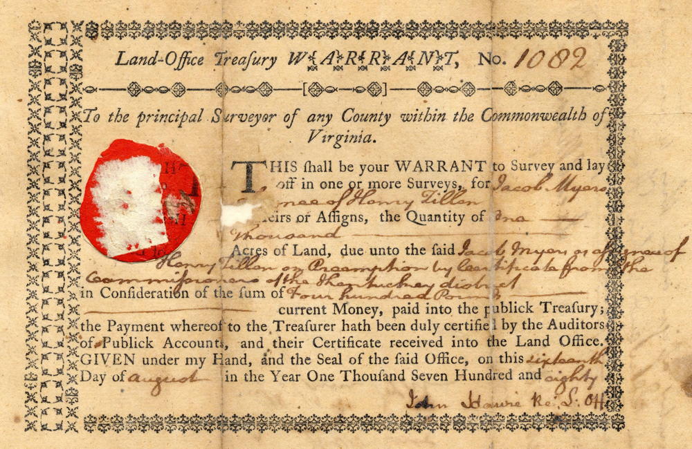
Jacob Myers next obtained a treasury warrant for the preemption on August 16th, as shown below.
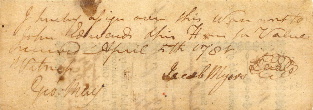
The following April, Myers signed that treasury warrant over to John Edwards, as shown below.
It appears that Edwards also obtained Myers' right to the settlement first obtained by Tillen, for in 1783 he had both the settlement of 400 acres and preemption of 1000 acres drawn on the south side of Salt River. The surveys and related deeds are shown below. Then soon afterwards, Patrick McGee purchased the land from Edwards, and it was here that he and Ben Pope built a cabin.
400 Acre Settlement Survey
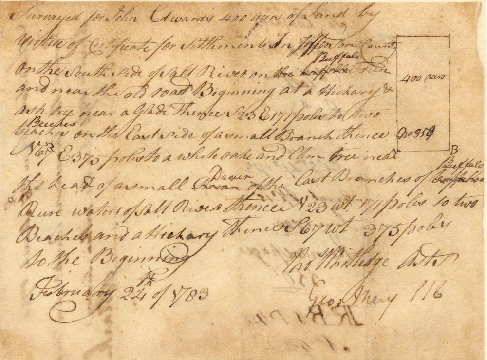
Surveyed for John Edwards 400 acres of land by virtue of certificate for settlement in Jefferson County on the south side of Salt River on Buffalo Run and near the old road. Beginning at a hickory and ash tree near a glade, thence S 23 degrees E 171 poles to two beeches on the East side of a small branch, thence N 67 degrees E 375 poles to a white oak and elm tree near the head of a small drain of the East branch of Buffalo Run waters of Salt River, N 23 degrees W 171 poles to two beeches and hickory, thence S 67 degrees W 375 poles to the Beginning; February 22, 1783. (signed) Thos Whitledge, Asst Surveyor
400 Acre Settlement Deed
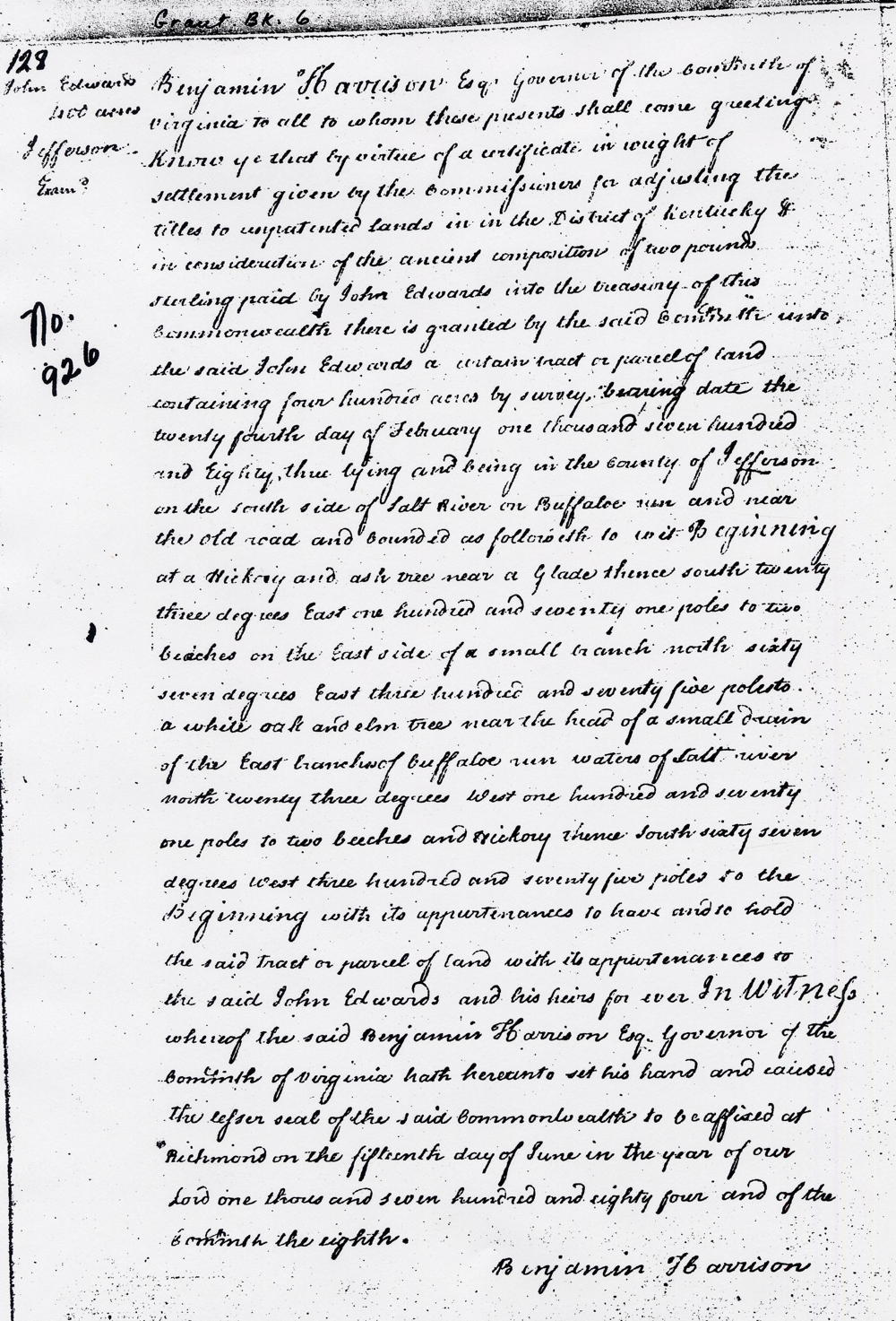
Grant Book 6, page 128
Benjamin Harrison Esq, Governor of the Commonwealth of Virginia to all to whom these presents shall come, greetings. Know ye that by virtue of a certificate in weight of settlement given by the commissioners for adjusting the titles to unpatiented lands in the District of Kentucky, & in consideration of the ancient composition of two pound sterling paid by John Edwards into the treasury of this commonwealth, there is granted by the said committee unto the said John Edwards a certain tract or parcel of land containing four hundred acres by survey bearing date the twenty fourth day of February one thousand seven hundred and eighty three, lying and being in the county of Jefferson on the south side of Salt River on Buffalo Run and near the old road, and bounded as followeth, to wit; Beginning at a hickory and ash tree near a glade, thence South twenty three degrees East one hundred and seventy one poles to two beeches on the East side of a small branch, North sixty seven degrees East three hundred and seventy five poles to a white oak and elm tree near the head of a small drain of the East branch of Buffalo Run waters of Salt River, North twenty three degrees West one hundred and seventy one poles to two beeches and hickory, thence South sixty seven degrees West three hundred and seventy five poles to the Beginning with its appurtenances to have and to hold the said tract or parcel of land with its appurtenances to the said John Edwards and his heirs forever. In witness whereof the said Benjamin Harrison Esq, Governor of the Commonwealth of Virginia hath hereunto set his hand and caused the lesser seal of the said Commonwealth to be affixed at Richmond on the fifteenth day of June in the year of our Lord one thousand seven hundred and eighty fourth and of the Commonwealth the eighth. (signed) Benjamin Harrison
560 Acre Part of Preemption Survey
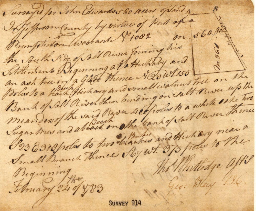
Surveyed for John Edwards 560 acres of land in Jefferson County by virtue of part of a preemption warrant No. 1082 on the south side of Salt River joining his settlement. Beginning at a hickory and an ash tree in a glade, thence N 23 W 155 poles to a beech, hickory and small walnut tree on the bank of Salt River, then binding on Salt River up the meanders of the said river 400 poles to a white oak, two sugar trees and a beech on the bank of Salt River, thence S 23 E 318 poles to two beeches and hickory near a small branch, thence S 67 W 375 poles to the Beginning. February 22, 1783 (signed) Thos Whitledge, Assistant Surveyor
560 Acre Part of Preemption Deed
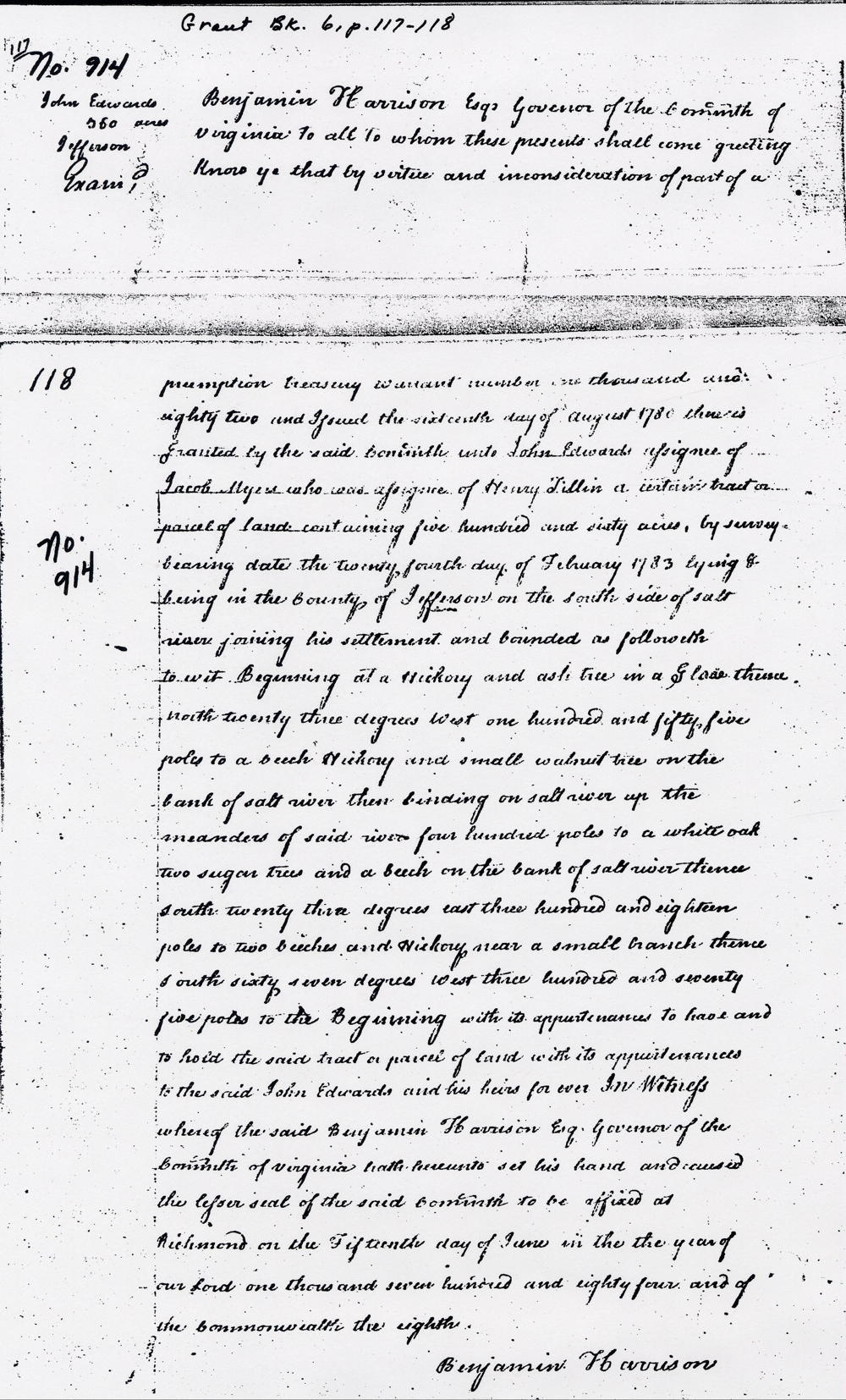
Grant Book 6, pp 117-118
Benjamin Harrison Esq, Governor of the Commonwealth of Virginia to all to whom these presents shall come, greeting. Know ye that by virtue and in consideration of part of a preemption treasury warrant number one thousand and eighty two and issued the sixteenth day of August 1780, there is granted by the said Commonwealth unto John Edwards, assignee of Jacob Myers who was assignee of Henry Tillin a certain tract or parcel of land containing five hundred and sixty acres by survey bearing date the twenty fourth day of February 1783 lying & being in the county of Jefferson on the south side of Salt River joining his settlement and bounded as followeth to wit. Beginning at a hickory and ash tree in a glade, thence North 23 degrees West one hundred and fifty five poles to a beech, hickory and small walnut tree on the bank of Salt River, then binding on Salt River up the meanders of said river four hundred poles to a white oak, two sugar trees and a beech on the bank of Salt River, thence South degrees 23 East three hundred and eighteen poles to two beeches and hickory near a small branch, thence South sixty seven degrees West three hundred and seventy five poles to the Beginning with its appurtenances to have and to hold the said tract or parcel of land with its appurtenances to the said John Edwards and his heirs forever. In witness whereof the said Benjamin Harrison Esq, Governor of the Commonwealth of Virginia hath hereunto set his hand and caused the lesser seal of the said Commonwealth to be affixed at Richmond on the fifteenth day of June in the year of our Lord one thousand seven hundred and eighty four and of the Commonwealth the eighth. (signed) Benjamin Harrison
440 Acre Part of Preemption Survey
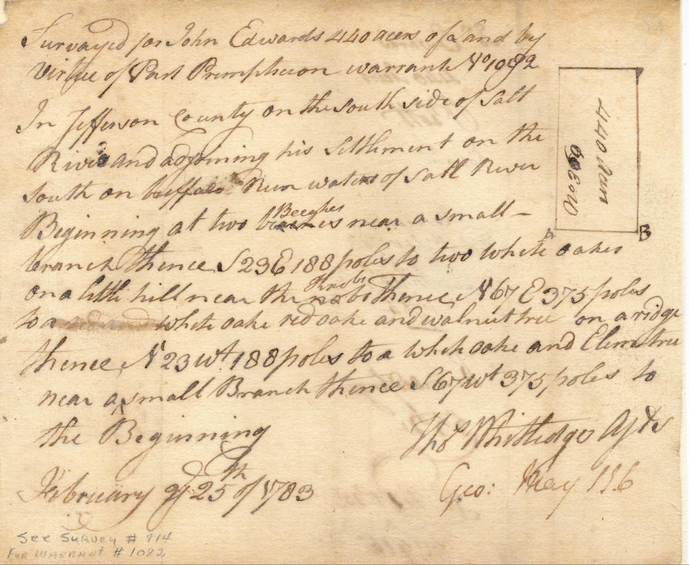
Surveyed for John Edwards 440 acres of land by virtue of part preemption warrant No. 1082 in Jefferson County on the south side of Salt River and adjoining his settlement on the south on Buffalo Run waters of Salt River. Beginning at two beeches near a small branch, thence S 23 E 188 poles to two white oaks on a little hill near the knobs, thence N 67 E 375 poles to a white oak, red oak and walnut tree on a ridge, thence N 23 W 188 poles to a white oak and elm tree near a small branch, thence S 67 W 375 poles to the Beginning. February 25, 1783 (signed) Thos Whitledge, Assistant Surveyor
440 Acre Part of Preemption Deed
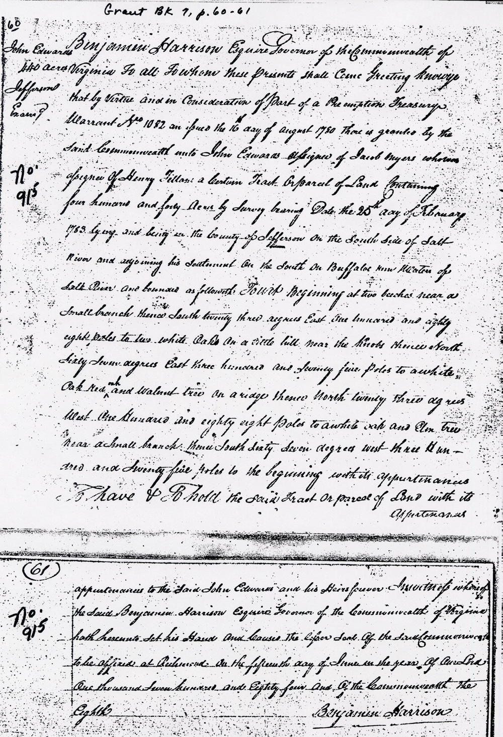
Grant Book 7, pp 60-61
Benjamin Harrison Esq, Governor of the Commonwealth of Virginia to all to whom these presents shall come, greeting. Know ye that by virtue and in consideration of part of a preemption treasury warrant number 1082 and issued the 16th day of August 1780, there is granted by the said Commonwealth unto John Edwards, assignee of Jacob Myers who was assignee of Henry Tillim a certain tract or parcel of land containing four hundred and forty acres by survey bearing date the 25th day of February 1783, lying and being in the county of Jefferson on the south side of Salt River and adjoining his settlement on the south on Buffalo Run waters of Salt River and bounded as followeth, to wit. Beginning at two beeches near a small branch, thence South twenty three degrees East one hundred and eighty eight poles to two white oaks on a little hill near the knobs, thence North sixty seven degrees East three hundred and seventy five poles to a white oak, red oak and walnut tree on a ridge, thence North twenty three degrees West one hundred and eighty eight poles to a white oak and elm tree near a small branch, thence South sixty seven degrees West three hundred and seventy five poles to the Beginning with it appurtenances to have and to hold the said tract or parcel of land with it appurtenances to the said John Edwards and his heirs forever. In witness whereof the said Benjamin Harrison Esq, Governor of the Commonwealth of Virginia hath hereunto set his hand and caused the lesser seal of the said Commonwealth to be affixed at Richmond on the fifteenth day of June in the year of our Lord one thousand seven hundred and eighty four and of the Commonwealth the eighth. (signed) Benjamin Harrison
If you, the reader, have an interest in any particular part of our county history, and wish to contribute to this effort, use the form on our Contact Us page to send us your comments about this, or any Bullitt County History page. We welcome your comments and suggestions. If you feel that we have misspoken at any point, please feel free to point this out to us.
The Bullitt County History Museum, a service of the Bullitt County Genealogical Society, is located in the county courthouse at 300 South Buckman Street (Highway 61) in Shepherdsville, Kentucky. The museum, along with its research room, is open 10 a.m. to 4 p.m. Monday through Friday. Saturday appointments are available by calling 502-921-0161 during our regular weekday hours. Admission is free. The museum, as part of the Bullitt County Genealogical Society, is a 501(c)3 tax exempt organization and is classified as a 509(a)2 public charity. Contributions and bequests are deductible under section 2055, 2106, or 2522 of the Internal Revenue Code. Page last modified: 04 Sep 2025 . Page URL: bullittcountyhistory.org/bchistory/john-edwards.html