
John Helm surveyed 1000 acres for John Hurst on 13 Mar 1788. The tract lay along the Rolling Fork River, and straddled Wilson's Creek The survey and deed along with their transcriptions are shown below.
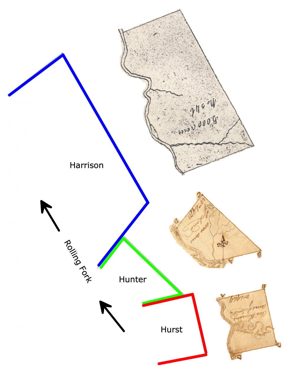
This drawing shows the relationship of this tract with that of two other tracts downstream from it. The first was 1000 acres surveyed for John Hunter; the second was 5000 acres for Cuthbert Harrrison.
Survey
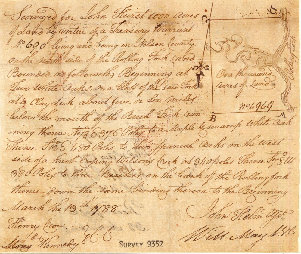
Surveyed for John Hurst 1000 acres of land by virtue of a treasury warrant No. 690 lying and being in Nelson County on the north side of the Rolling Fork and bounded as followeth, Beginning at two white oaks on a bluff of the said fork at a clay lick, about five or six miles below the mouth of the Beech Fork, running thence N 78° E 376 poles to a maple & swamp white oak, thence S 12° E 480 poles to two Spanish oaks on the west side of a knob crossing Wilson's Creek at 340 poles, thence S 78° W 380 poles to three beeches on the bank of the Rolling Fork, thence down the same binding thereon to the beginning. John Helm, surveyor. Henry Crow & Moses Kennedy, chain carriers. March the 13th 1788
Deed
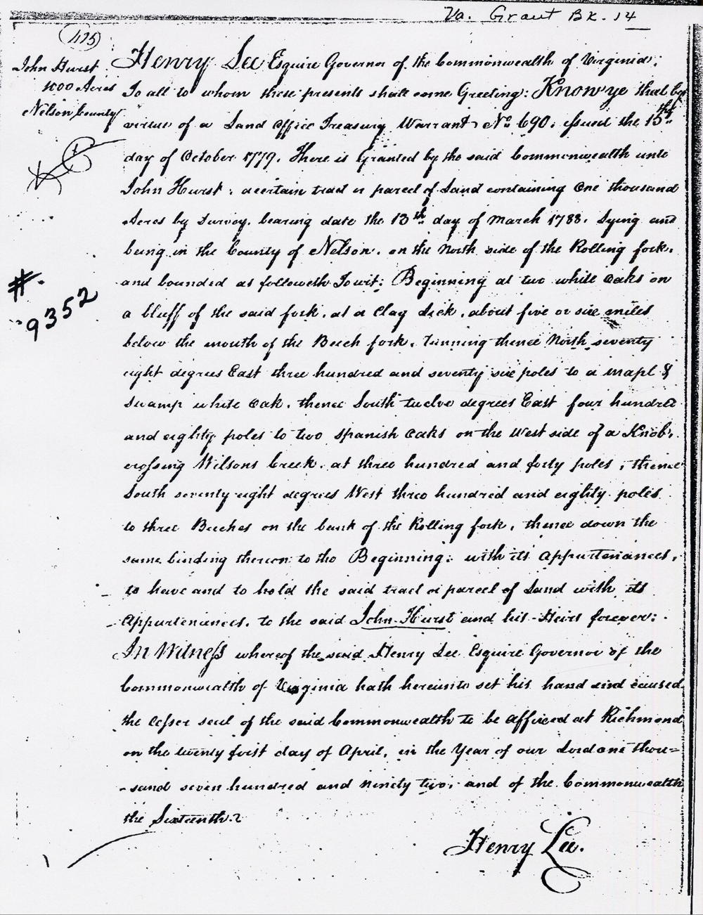
Virginia Grant Book 14, page 475
Henry Lee Esquire, Governor of the Commonwealth of Virginia, to all to whom these presents shall come, greeting. Know ye that by virtue and in consideration of a land office treasury warrant numbered 690 and issued the 15th day of October 1779 there is granted by the said Commonwealth unto John Hurst a certain tract or parcel of land containing one thousand acres by survey bearing date the 13th day of March, 1788, lying and being in the County of Nelson on the north side of the Rolling Fork, and bounded as followeth, to wit. Beginning at two white oaks on a bluff of the said fork, at a clay lick about five or six miles below the mouth of the Beech Fork, running thence North 78 degrees East 376 poles to a maple & swamp white oak, thence South 12 degrees East 480 poles to two Spanish oaks on the west side of a knob, crossing Wilson's Creek at 340 poles, thence South 78 degrees West 380 poles to three beeches on the bank of the Rolling Fork, thence down the same binding thereon to the beginning with it appurtenance to have and to hold the said tract or parcel of land with its appurtenances to the said John Hurst and his heirs forever. In witness whereof, the said Henry Lee Esquire, Governor of the Commonwealth of Virginia, hath hereunto set his hand and caused the lesser seal of the said Commonwealth to be affixed at Richmond on the 21st day of April in the year of our Lord 1792 and of the Commonwealth the 16th. (signed) Henry Lee
If you, the reader, have an interest in any particular part of our county history, and wish to contribute to this effort, use the form on our Contact Us page to send us your comments about this, or any Bullitt County History page. We welcome your comments and suggestions. If you feel that we have misspoken at any point, please feel free to point this out to us.
The Bullitt County History Museum, a service of the Bullitt County Genealogical Society, is located in the county courthouse at 300 South Buckman Street (Highway 61) in Shepherdsville, Kentucky. The museum, along with its research room, is open 10 a.m. to 4 p.m. Monday through Friday. Saturday appointments are available by calling 502-921-0161 during our regular weekday hours. Admission is free. The museum, as part of the Bullitt County Genealogical Society, is a 501(c)3 tax exempt organization and is classified as a 509(a)2 public charity. Contributions and bequests are deductible under section 2055, 2106, or 2522 of the Internal Revenue Code. Page last modified: 12 Sep 2024 . Page URL: bullittcountyhistory.org/bchistory/john-hurst9352.html