
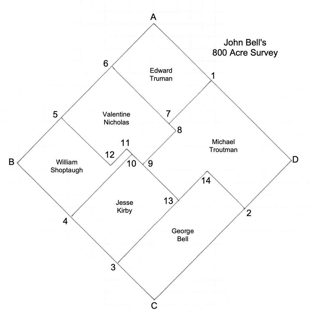
Isaac Cox surveyed this 800 acre tract on the west side of the West Fork of Cox's Creek for John Bell on 5 Feb 1784, who received the deed for it on 2 Dec 1785.
He sold the first part of it to Edward Truman on 24 Oct 1797. On 5 Feb 1802, he then sold much of the rest to four men: George Bell, Jesse Kirby, Valentine Nicholas, and William Shoptaugh. Finally, he sold the last part to Michael Troutman's tract on 28 Sep 1808.
The drawing to the right shows how his survey was divided among these men. The survey and deed are transcribed below.
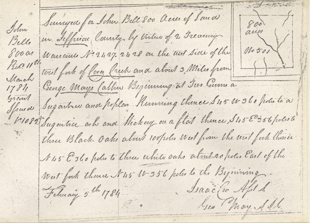
Survey
Surveyed for John Bell 800 acres of land in Jefferson County by virtue of 2 treasury warrants No. 2427, 2428 on the west side of the west fork of Cox's Creek and about 3 miles from George May's cabin, beginning at two gum, a sugar tree and poplar, running thence S 45 W 360 poles to a sugar tree, ash and hickory on a flat, thence S 45 E 356 poles to three black oaks about 100 poles west from the west fork, thence N 45 E 360 poles to three white oaks about 20 poles east of the west fork, thence N 45 W 356 poles to the beginning. February 5th 1784. Isaac Cox, surveyor.
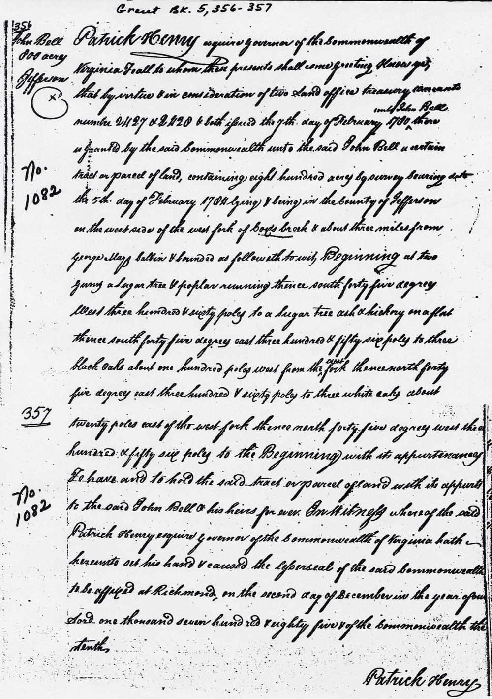
Deed
Virginia Grant Book 5, pages 356-7
Patrick Henry Esquire, Governor of the Commonwealth of Virginia, to all to whom these presents shall come, greeting. Know ye that by virtue of and in consideration of two land office treasury warrant numbers 2427 and 2428 and both issued the the seventh day of February 1780 unto John Bell there is granted by the said Commonwealth unto the said John Bell a certain tract or parcel of land containing 800 acres by survey bearing date the fifth day of February 1784, lying and being in the county of Jefferson on the west side of the west fork of Cox's Creek & about three miles from George May's cabin, and bounded as followeth, to wit. Beginning at two gums, a sugar tree & poplar running thence South 45° West 360 poles to a sugar tree, ash and hickory on a flat, thence South 45° East 356 poles to three black oaks about 100 poles west from the west fork, thence North 45° East 360 poles to three white oaks about 20 poles east of the west fork, thence North 45° West 356 poles to the beginning with its appurtenances to have and to hold the said tract or parcel of land with its appurtenances to the said John Bell & his heirs forever. In witness whereof the said Patrick Henry Esquire, Governor of the Commonwealth of Virginia, hath hereunto set his hand and caused the lesser seal of the said Commonwealth to be affixed at Richmond on the second day of December in the year of our Lord one thousand seven hundred and eighty five & of the Commonwealth the tenth. (signed) Patrick Henry
If you, the reader, have an interest in any particular part of our county history, and wish to contribute to this effort, use the form on our Contact Us page to send us your comments about this, or any Bullitt County History page. We welcome your comments and suggestions. If you feel that we have misspoken at any point, please feel free to point this out to us.
The Bullitt County History Museum, a service of the Bullitt County Genealogical Society, is located in the county courthouse at 300 South Buckman Street (Highway 61) in Shepherdsville, Kentucky. The museum, along with its research room, is open 10 a.m. to 4 p.m. Monday through Friday. Saturday appointments are available by calling 502-921-0161 during our regular weekday hours. Admission is free. The museum, as part of the Bullitt County Genealogical Society, is a 501(c)3 tax exempt organization and is classified as a 509(a)2 public charity. Contributions and bequests are deductible under section 2055, 2106, or 2522 of the Internal Revenue Code. Page last modified: 04 Sep 2025 . Page URL: bullittcountyhistory.org/bchistory/johnbell1082.html