
The following tracts located around Pond Creek in Jefferson County were obtained by Joseph Brooks via patents which he obtained primarily by negotiations with others, or by transactions with others.
Robert Daniel to Joseph Brooks - 500 Acres - 6 Mar 1792
Jefferson DB 2 Pg 340
Robert Daniel to Joseph Brooks, both of Jefferson County, 500 acres, and undivided moiety of 1000 acres surveyed by Samuel Shannon and conveyed to said Robert, beginning near Banackman's Lick, corner to Gullet's 400 acres, thence south and west to Allen Davis's line, thence east to a 1000 acre tract surveyed in names of Richard McMahan and Benjamin Johnston, thence east to a post in original line of said tract. Acknowledged in court on 6 Mar 1792.
Isaac Hite to Joseph Brooks - Articles of Agreement - 3 Apr 1792
Jefferson DB 3 Pg 3
To said Joseph Brooks, 800 acres of land in Jefferson County, part of 2000 acre tract near Mann's Lick patented by Leven Powell, in Hite's name and is no wise bound to Brooks for a title to same, but is willing to convey his interest in the 800 acres without being liable for a defective title. Recorded 3 Apr 1792.
Isaac Hite to Joseph Brooks - 800 Acres - 3 Apr 1792
Jefferson DB 3 Pg 5
Indenture from Isaac Hite to Joseph Brooks, assignee of William Oldham & James Sullivan. To said Brooks in consideration of the said Oldham and Sullivan locating and surveying 3000 acres for Leven Powell of Loudoun County, and some money, one 800 acre tract of land in Jefferson County, being a part of a 2000 acre tract granted to Leven Powell by patent 14 Jul 1789, and conveyed by Powell to Hite, deed dated 25 Oct 1791, beginning in line of said 2000 acres, thence north to said 2000 acres. Recorded 3 Apr 1792.
Isaac Hite to Joseph Brooks - 1000 Acres - 7 Aug 1792
Jefferson DB 3 Pg 25
To said Joseph Brooks for money consideration, one tract of 1000 acres in Jefferson County on waters of Pond Creek, part of 2000 acres conveyed to Hite by Leven Powell 25 Oct 1791, its westwardly part in line of John Todd's property. Recorded 7 Aug 1792
Isaac Hite and Joseph Brooks - Mortgage - 7 May 1793
Jefferson DB 4 Pg 19
Brooks by six bonds of 6 Sep 1793, stands bound to Hite in sum of 15000 for the payment of 5,000 bushels of salt to be delivered to Mann's Lick. In consideration of said debt, Brooks sells to Hite two 1000 acre tracts on Pond Creek previously conveyed to him by Hite. Void if debt paid. Recorded 7 May 1793.
Joseph Brooks - [OK-0157] - 90 acres - 10 May 1793
A Treasury Warrant No. 12183 was issued to James Quartermous on 5 Jun 1782, who assigned it to Joseph Brooks "for value received," date not given.
On 4 Dec 1781, the Jefferson County Court issued an order for James Steward to receive 400 acres, agreeable to an act of assembly regarding the poor. Steward assigned his right to the certificate to Meredith Price who then assigned it to Joseph Brooks on 20 Dec 1783 "for value received."
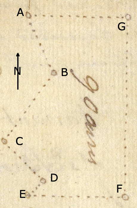
Joseph Brooks then used parts of each to obtain 90 acres located on the northwest side of a large pond that ran from Flat Lick to Pond Creek in Jefferson County. It was surveyed by Robert Breckinridge on 1 Dec 1792, and Brooks received his deed on 10 May 1793, signed by Governor Isaac Shelby.
The survey is transcribed below, with reference to the drawing shown here.
Surveyed for Joseph Brooks 90 acres of land upon two entries (viz) one of 50 acres dated the 5th day of December 1790 on part of a treasury warrant No. 12183, & the residue (40 acres) on part of an entry of 75 acres dated the 26th of April 1791, on part of a poor certificate, lying in Jefferson County on the NW side of a large pond that runs from the Flat Lick to Pond Creek. Beginning at a maple at [A] the intersection of the South boundary of Henry West's 800 acre tract with the line of Richard McMahan's 1000 acre tract, thence down the pond with McMahan's line S 25° E 56 poles to [B] a black oak, maple & white oak, S 35° W 80 poles to [C] a black oak & two beeches, S 45° E 52 poles to [D] two white oaks & an ash, S 45° W 25 poles to [E] a maple corner of James Garrard's 2018 acre survey, thence with the line thereof East 90 poles to [F] a stake in the pond, corner of said 2018 acre tract, thence North 160 poles [G]to a stake in the pond & in a line of said West's land, & with the same West 90 poles to the beginning. Robert Breckinridge, surveyor; December 1, 1792.
Joseph Brooks - [OK-0138] - 103 acres - 10 May 1793
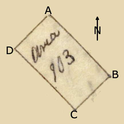
On 2 Nov 1792, James F. Moore surveyed 103 acres on the waters of Pond Creek for Bracket Owings who then signed the tract over to Moore "for value received." Moore then, the same day, signed it over to Joseph Brooks who received his deed for the tract on 10 May 1793.
The survey is transcribed below, with reference to the drawing shown here.
Surveyed for Bracket Owings one hundred & three acres of land in Jefferson County by virtue of a treasury warrant No. 14108 on the waters of Pond Creek adjoining the land of James Speed on the southwest. Beginning at [A] three ash trees corner to said Speed S 45° E 170 poles to [B] a beech, S 45° W 97 poles to [C] a beech, N 45° W 170 poles to [D] a white ash and hoop ash, N 45° E 97 poles to the beginning. James F. Moore, surveyor. November 2nd 1792.
James Sullivan and Joseph Brooks - Obligation - 1 Oct 1793
Jefferson DB 4 Pg 93
On 20 Aug 1790, an agreement was made between Will Oldham and the said James Sullivan of one part and said Brooks of other part, whereby Brooks had bought 800 acres, part of 2000 acres entered by Dan Sullivan and William Oldham for Colonel Leven Powell, adjoining Mann's Lick, a deed had been issued to Brooks by Isaac Hite, and Brooks fears he may be evicted from part of the 2000 acres sold him by Sullivan by the heirs of said Dan Sullivan deceased who was jointly entitled to 400 acres thereof with William Oldham for locating the land. Should James Sullivan secure Brooks from all demands to one moiety of said 800 acres, being the part sold to him by James Sullivan, then this obligation to be void. Recorded 1 Oct 1793.
Joseph Brooks to Robert Breckinridge and Thomas Carneal - Mortgage - 4 Mar 1794
Jefferson DB 4, Pg 111
To Robert Breckinridge and Thomas Carneal for money consideration, paid Joseph Brooks and referring to sundry obligations: 1 of 24 Jan 1793, 1 of 3 Apr 1793, 1 of 5 Oct 1793, payable to said Robert Breckinridge and also 20 and 4 obligations, each of 2084 lbs of salt, dated 25 Feb 1794, payable monthly until the whole are discharged, executed to the said Thomas Carneal, do by these presents sell unto the said Robert Breckinridge and Thomas Carneal, one tract of land in Jefferson County on Floyd's Fork, six miles north of Bullitt's Lick, held in virtue of part of a settlement, and preemption and a preemption of 400 acres aliened by Major Beasley and Thomas Philips to the said Brooks, beginning at the corner of Christian and Sanders' land of 970 acres, including the plantation whereon said Joseph Brooks lived, security for payment in money and salt. Should Brooks default in performance of said obligations, hen land to become the property of said Breckinridge and Carneal, heirs, etc. Recorded 4 Mar 1794.
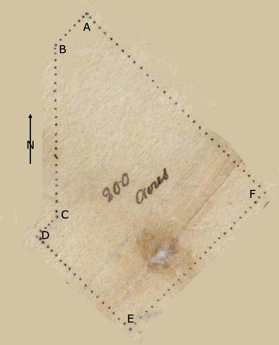
Joseph Brooks - [VA-8907] - 2018 acres - 1 Aug 1795
James Garrard had 2018 acres surveyed in Jefferson County on Pond Creek and on both sides of a large pond that ran from the Flat Lick to Pond Creek on 1 Dec 1790. He then assigned the tract to Joseph Brooks who received a deed for it on 1 Aug 1795.
The survey is transcribed below, with reference to the drawing shown here.
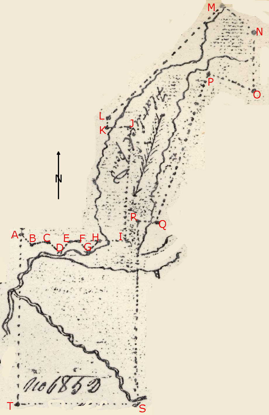
Surveyed for James Garrard 2018 acres of land by virtue of a treasury warrant No. 10446, lying in Jefferson County on Pond Creek and on both sides of a large pond that runs from the Flat Lick to Pond Creek. Beginning at [A]an elm, hickory and black oak in a line of McMahan's 1000 acre survey on the northwest side of the pond, thence with a line thereof S 45° E 48 poles to [B] two white oak and a beech corner to McMahan, thence N 80° E 50 poles to [C] a beech, elm and ash corner to McMahan, thence S 45° E 46 poles to [D] two beeches and a sugar tree corner to McMahan, thence N 45 E 40 poles to [E] three beeches marked I.B. in McMahan's line, thence East 20 poles to [F] a beech in another of Mahan's lines and with the same South 45° E 40 poles to [G] the corner (two elms, a beech & ash), thence N 45° E 44 poles to [H] a maple in McMahan's line, thence East 91 poles to [I] a stake in the pond, thence North 358 poles [J] in the pond, thence West 71 poles to [K] a beech in said McMahan's line, thence with the same N 10° E 32 poles to [L] a poplar, sweet gum and white oak corner to said McMahan and Peter Bellie's 400 acre tract, thence with Bellie's line and a line lf Allen Davis' 300 acre tract N 45° E 504 poles to [M] two maples and a swamp ash in said Davis' line corner to Samuel Shannon's 1233 1/2 acre survey, thence with a line thereof S 50° E 132 poles to [N] two maples and a swamp ash corner to Richard McMahan and Ben Johnson's 1000 acre survey, thence with a line thereof South 180 poles to [O] a beech in the line of Leven Powell's 2000 acre survey, thence with the same N 70° W 135 poles to [P] three elms and an ash near a beaver dam corner to Powell, thence with another line S 20° W 482 poles to [Q] a beech in said line, thence West 69 poles to [R] a stake in the pond, thence South 580 poles to [S] two beeches and a gum on the point of a grassy ridge near to and on the west side of a drain of the Bec lick run, thence W 354 poles to [T] a .. chestnut oak, white oak and hickory on a high ridge, thence North 220 poles crossing the Bec lick run and Pond Creek near the junction to the beginning. December 1st 1790. Robert Breckinridge, surveyor.
Joseph Brooks - [VA-8906] - 2000 acres - 1 Aug 1795
William Garrard had 2000 acres surveyed in in Jefferson County on the waters of Pond Creek on 2 Dec 1790. He then assigned the tract to Joseph Brooks who received a deed for it on 1 Aug 1795.
The survey is transcribed below, with reference to the drawing shown here.
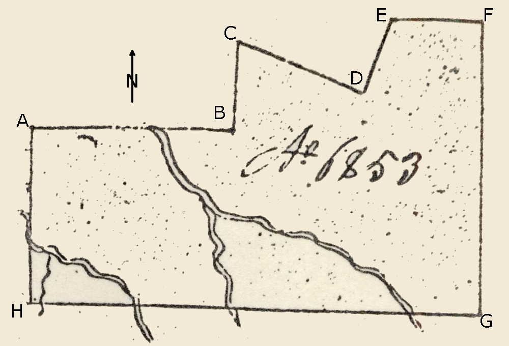
Surveyed for William Garrard 2000 acres of land by virtue of a treasury warrant No. 10441, lying in Jefferson County on the waters of Pond Creek adjoining James Garrard's 2018 acre survey on the east, beginning at [A] an elm, beech and sugar tree on a ridge and in a line of said James Garrard's land, thence East 359 poles to [B] a white oak and two maples marked I.B., thence North 158 poles to [C] a white oak, ash and sweet gum in the line of Leven Powell's 2000 acre survey, thence with the same S 70° E 238 poles to [D] two black oaks and a white oak corner to said Powell, thence N 20° E 142 poles to [E] four beeches corner to Osborn Sprigg's survey of 1100 acres, thence with the line thereof East 160 poles to [F] three elms and a beech, thence South 223 poles passing a deer lick at 44 poles to [G] two white oaks and a maple at the foot of a pine knob by a small drain, thence West 800 poles crossing Chapman's run at 210 poles, a fork of same at 450 poles and the Bee Lic run at 610 poles to [H] two ashes and a beech at the foot of a ridge and on the east side thereof, thence North 310 poles crossing the Bee Lick Run to the beginning. Robert Breckinridge, surveyor. December 2nd 1790.
Joseph Brooks - [OK-1092] - 200 acres - 13 Dec 1795
James Buchanan had 200 acres on the northwest side of Pond Creek surveyed by Alexander Breckinridge on 7 May 1795. This appears to be part of the land sold to Joseph Brooks by Buchanan by an earlier contract, described below. Brooks obtained deed to this tract on 13 Dec 1795.
Found with this survey and deed is the following copy of Buchanan's entry.
"1789 August 14th. James Buchanan enters 1260 acres of land, 1000 acres thereof upon part of a treasury warrant No. 19202 & the balance on a treasury warrant No. __ on the north west side of Pond Creek adjoining Jacob Myers 900 acre survey on the south east and south west - his 2000 acres on the south east and south west, Robert Coleman's 12231 acre survey on the north west to John Woolfolk's entry of 4000 acres & to run with his entry north west and the said Myers' 2000 acre survey for quantity. A copy. Teste. (signed) A. Breckinridge, SJC"
On its back was recorded the following:
"13 Dec 1795. 935 acres of the within entry has been surveyed, a grant obtained for the same & sold to Joseph Brooks agreeable to a contract dated the 5th day of February 1795, and the said Brooks being desirous to have the balance of the said entry (325 acres) assigned to him, it is accordingly by these presents transfered to the said Brooks, his heirs and assigns forever, upon this condition that it is not to be considered as appendant to the contract before mentioned, nor to effect the same in any manner whatever. And also upon condition that in the event of the said 325 acres being losed by interfering claims the said Brooks is not to have remedy in damages, no consideration having been paid for the same. Witness my hand and seal this second day of April 1795. (signed) James Buchanan."
The survey is transcribed below, with reference to the drawing shown here.
Surveyed for James Buchanan 200 acres of land, being part of an entry of 1260 acres dated the 14th of August 1789, by virtue of two treasury warrants No. 19202 & No. __, lying in Jefferson County on the northwest side of Pond Creek, beginning at [A] two maples and an elm corner to a 900 acre survey that includes Bulger's Lick patented in the name of Jacob Myers running as hence and a line of the same South 45° West 40 poles to [B] the intersection with James Garrard's line, thence on the same South 160 poles to [C] a beech in said line, thence South 45° West 25 poles to [D] a bush in Robert Coleman's line, thence on the same South 45° East 120 poles to [E] a black oak and white oak corner to Sullivan and James, thence with their line North 45° East 180 poles to [F] a honey locust and elm corner to the said Sullivan and James and in a line of Joseph Brooks' 103 acre survey as assignee of J. F. Moore, thence on a line of the same and a line of Myers' 100 acre survey North 45° West 233 poles to the beginning. May 7th 1795. Alexander Breckinridge, surveyor.
Hugh Grimes to Joseph Brooks - 100 acres - 6 Oct 1796
Jefferson DB 4 Pg 430
Indenture 4 Oct 1776, between Hugh Grimes and Isabella his wife, of Jefferson County and Joseph Brooks: To said Brooks for money consideration, one tract of 100 acres in Jefferson County on waters of Pond Creek, being same land conveyed to Grimes by Richard McMahan by patent 7 Jun 1786, being the land where Grimes lived, beginning at Henry Ditto's corner in Morrison's line. Recorded 6 Oct 1796.
John Kinnison to Joseph Brooks - 150 acres - 6 Dec 1796
Jefferson DB 4 Pg 449
Indenture 8 Nov 1796 between John Kinnison and Sarah his wife of Jefferson County to Joseph Brooks of Jefferson County, to said Brooks for money consideration, one tract of 150 acres in Jefferson County, being same land conveyed to Kinnison by Richard McMahan by deed 1 Apr 1788, being part of 1000 acres on Pond Creek granted to Richard McMahan by patent 7 June 1786, beginning at Peter Bailey's lower corner, thence south and west to corner of Henry Ditto's land and thence south and west to Hugh Grimes' land. Recorded 6 Dec 1796.
William Johnston to Joseph Brooks - 500 acres - 7 Oct 1797
Jefferson DB 4 Pg 518
Indenture 26 Sep 1797, between William Johnston and Betsey his wife of Jefferson County and Joseph Brooks of Jefferson County. To said Brooks for money consideration the moiety or one half of 1000 acres of land patented in the name of Richard McMahon and Benjamin Johnston, said land in Jefferson County on Pond Creek. The moiety, by the death of said Benjamin, fell to his heirs, of which, at a division made among the heirs, 250 acres fell to William Johnston who sold it to John Harrison who sold it to Joseph Brooks, and the remaining 250 acres fell to Susanna Johnston who sold it to William who so it to Joseph. Recorded 7 Oct 1797.
Samuel Shannon to Joseph Brooks - 233 1/2 acres - 6 Jun 1798
Jefferson DB 4 Pg 602
Indenture 25 Sep 1797, between Samuel Shannon and Martha his wife of Shelby County and Joseph Brooks of Jefferson County. To Brooks for money considerations one tract on Pond Creek, part of a 1233 1/2 survey granted to Shannon as assignee of Wiliam Shannon by patent 5 May 1786, Shelby County 21 Nov 1797. Recorded 6 Jun 1798.
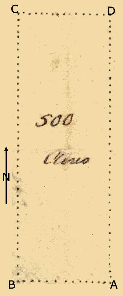
Samuel Shannon to Joseph Brooks - 1000 acres - 6 Jun 1798
Jefferson DB 4 Pg 602
Indenture 25 Sep 1797, between Samuel Shannon and Martha his wife of Shelby County and Joseph Brooks of Jefferson County. To Brooks for money considerations one tract on Pond Creek, one tract of 1000 acres, part of Shannon's 1223 1/2 acre survey, beginning at Barrackman's 400 acres, thence south and west to Allen Davis' line and thence to a corner of the 1000 acres of land surveyed for Richard McMahan and Benjamin Johnston. Recorded 6 Jun 1798.
Joseph Brooks and James Francis Moore - land exchange - 27 Aug 1800
On 27 Aug 1800, James Francis Moore and Joseph Brooks exchanged plots of land.
Brooks received 1682 acres, including 400 acres surveyed in the name of John Hamilton on a poor certificate, that began on the banks of Lick Creek where a line of James Speed's 600 acre survey crossed the creek, and then with many meanderings to where William Capman's meadow fence crossed the creek, then to a line of George Slaughter's 680 acre survey, then with a line of John G. Moore's 2198 acre survey, then with a line of Fielding Lewis' survey, then to a corner of land sold to Samuel Hutchinson and with his line to James McCawley's preemption, then to a line of land sold to Charles Beeler, then along the top of the knobs to Leven Powell's 2000 acre survey, and then to a line of Speed's 600 acre survey.
In exchange, Moore received 1973 1/4 acres along Pond Creek that was part of entries made in the names of William Garrard and James Garrard, including 103 acres patented in Brooks' name. These acres began at James Garrard's 2018 acre survey, then to an intersection of his line and a line of Robert Coleman's survey, then to the middle of Pond Creek, then to the east corner of Jacob Myers' 900 acre survey, then to William Garrard's 2000 acre survey.
Joseph Brooks - [OK-5295] - 500 acres - 8 Aug 1802
Robert Floyd had 500 acres surveyed on the waters of Floyd's Fork & the southern head branches of Pond Creek in 1785. At some point thereafter he assigned the tract to Joseph Brooks who obtained a deed for it on 8 Aug 1802.
The survey is transcribed below, with reference to the drawing shown here.
Surveyed for Robert Floyd 500 acres of land in Jefferson County on an entry dated the 13th day of April 1783, on a treasury warrant No. 8534, lying on the waters of Floyd's Fork & the southern head branches of Pond Creek, and bounded as followeth, to wit. Beginning at [A] a large white oak & hickory southwest corner of Fielding Lewis' 1000 acre survey, thence West 164 poles to [B] a white oak, black gum & red oak, thence North 488 poles to [C] three white oaks & black oak standing on the side of a ridge, thence East 164 poles to [D] a chestnut oak & three white oaks in the west line of said Lewis' tract, thence South on the said line 488 poles to the beginning. August 12th 1785. James F. Moore, surveyor.
If you, the reader, have an interest in any particular part of our county history, and wish to contribute to this effort, use the form on our Contact Us page to send us your comments about this, or any Bullitt County History page. We welcome your comments and suggestions. If you feel that we have misspoken at any point, please feel free to point this out to us.
The Bullitt County History Museum, a service of the Bullitt County Genealogical Society, is located in the county courthouse at 300 South Buckman Street (Highway 61) in Shepherdsville, Kentucky. The museum, along with its research room, is open 10 a.m. to 4 p.m. Monday through Friday. Saturday appointments are available by calling 502-921-0161 during our regular weekday hours. Admission is free. The museum, as part of the Bullitt County Genealogical Society, is a 501(c)3 tax exempt organization and is classified as a 509(a)2 public charity. Contributions and bequests are deductible under section 2055, 2106, or 2522 of the Internal Revenue Code. Page last modified: 12 Sep 2024 . Page URL: bullittcountyhistory.org/bchistory/joseph-brooks-lands.html