
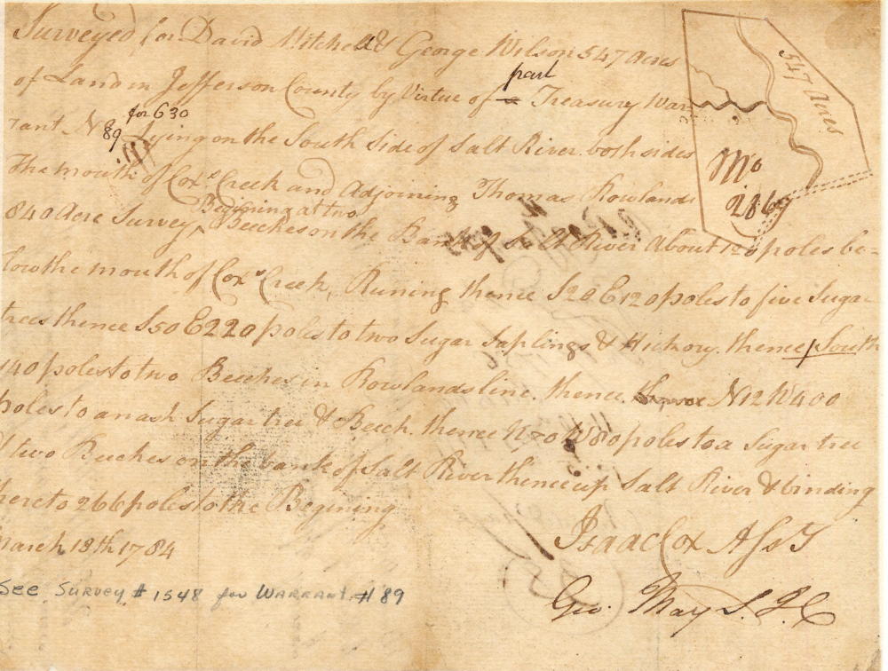
On 13 Mar 1784, Isaac Cox surveyed a tract of 547 acres at the mouth of Cox's Creek for David Mitchell and George Wilson. Mitchell and Wilson received their deed on 2 Feb 1786.
Certain elements of this survey were misrecorded, causing it to be somewhat confusing. In particular, at the third step in the boundary recording, Cox wrote that the direction was due south. However, the only way this makes any sense is if the direction is actually due east. Using this measures, with necessary corrections, we have attempted to plot this tract [A] on a drawing below, along with an adjoining one [B] upstream for Gabriel Cox. Henry Crist had the one marked [C].
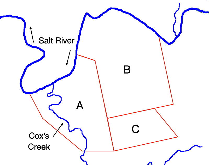
It may be helpful, when viewing the original survey drawing below, to remember that the tract is actually located south of Salt River, and that the top of the drawing is generally south, rather than north.
Survey
Surveyed for David Mitchell & George Wilson 547 acres of land in Jefferson County by virtue of part of a treasury warrant No. 89 for 630 lying on the south side of Salt River, both sides the mouth of Cox's Creek and adjoining Thomas Rowland's 840 acre survey. Beginning at two beeches on the bank of Salt River about 120 poles below the mouth of Cox's Creek, running thence S 28 E 120 poles to five sugar trees, thence S 50 E 220 poles to two sugar saplings & hickory, thence South 140 poles to two beeches in Rowland's line, thence N 12 W 400 poles to an ash, sugar tree & beech, thence N 70 W 80 poles to a sugar tree & two beeches on the bank of Salt River, thence up Salt River & binding thereto 266 poles to the beginning. March 13th 1784. Isaac Cox, Surveyor.
Deed
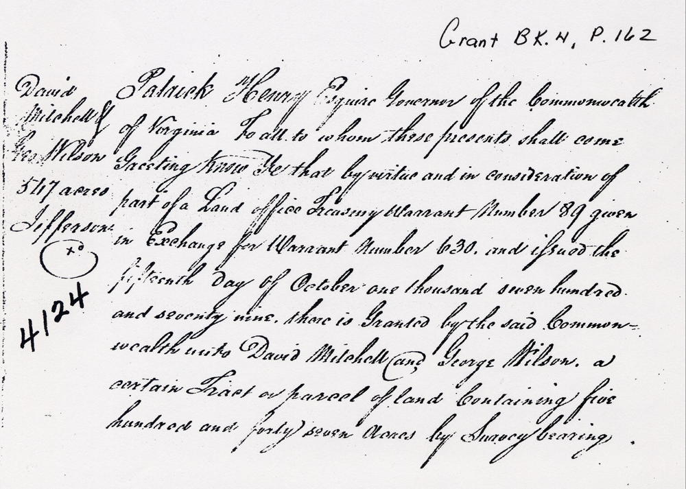
Virginia Grant Book 4, pages 162-3
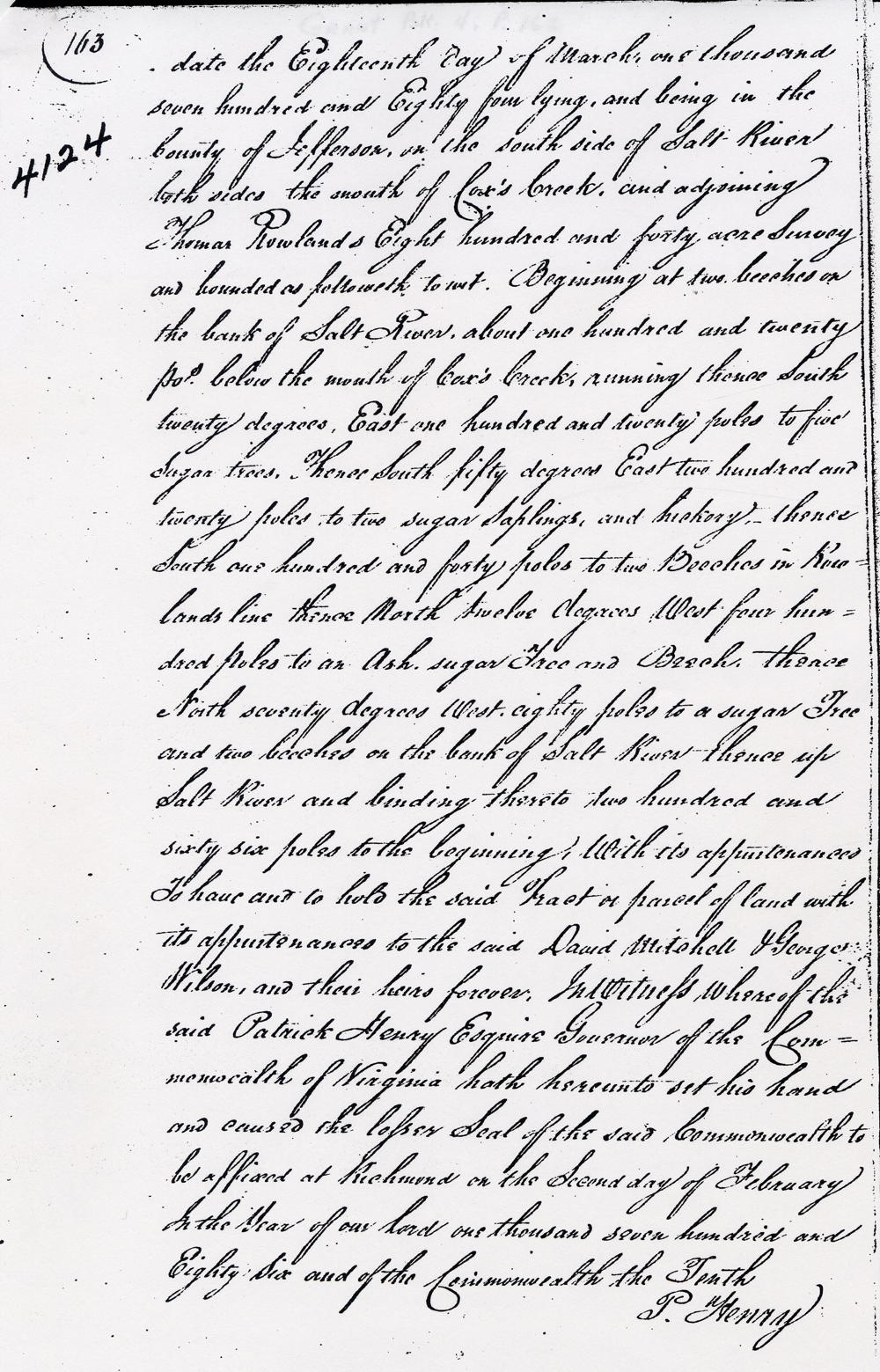
Patrick Henry Esquire, Governor of the Commonwealth of Virginia, to all to whom these presents shall come, greeting. Know ye that by virtue and in consideration of part of a land office treasury warrant number 89 given in exchange for a warrant number 630 and issued the 15th day of October 1779, there is granted by the said Commonwealth unto David Mitchell and George Wilson a certain tract or parcel of land containing 547 acres by survey bearing date the 18th day of March 1784, lying and being in the County of Jefferson, on the south side of Salt River both sides the mouth of Cox's creek and adjoining Thomas Rowland's 840 acres survey and bounded as followeth, to wit. Beginning at two beeches on the bank of Salt River about 120 poles below the mouth of Cox's Creek, running thence South 28° East 120 poles to five sugar trees, thence South 50° East 220 poles to two sugar saplings & hickory, thence South 140 poles to two beeches in Rowland's line, thence North 12° West 400 poles to an ash, sugar tree & beech, thence North 70° West 80 poles to a sugar tree & two beeches on the bank of Salt River, thence up Salt River & binding thereto 266 poles to the beginning with its appurtenances to have and to hold the said tract or parcel of land with its appurtenances to the said David Mitchell & George Wilson, and their heirs forever. In witness whereof the said Patrick Henry Esquire, Governor of the Commonwealth of Virginia, hath hereunto set his hand and caused the lesser seal of the said Commonwealth to be affixed at Richmond on the Second day of February in the year of our Lord one thousand seven hundred and eighty six, and of the Commonwealth the tenth. (signed) P. Henry
If you, the reader, have an interest in any particular part of our county history, and wish to contribute to this effort, use the form on our Contact Us page to send us your comments about this, or any Bullitt County History page. We welcome your comments and suggestions. If you feel that we have misspoken at any point, please feel free to point this out to us.
The Bullitt County History Museum, a service of the Bullitt County Genealogical Society, is located in the county courthouse at 300 South Buckman Street (Highway 61) in Shepherdsville, Kentucky. The museum, along with its research room, is open 10 a.m. to 4 p.m. Monday through Friday. Saturday appointments are available by calling 502-921-0161 during our regular weekday hours. Admission is free. The museum, as part of the Bullitt County Genealogical Society, is a 501(c)3 tax exempt organization and is classified as a 509(a)2 public charity. Contributions and bequests are deductible under section 2055, 2106, or 2522 of the Internal Revenue Code. Page last modified: 10 May 2026 . Page URL: bullittcountyhistory.org/bchistory/mitchell-wilson-coxcreek.html