
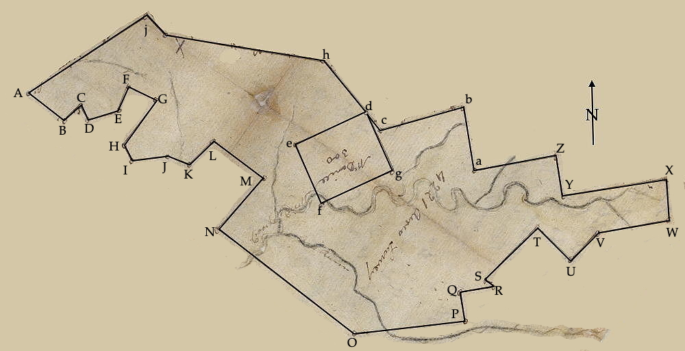
On 14 Oct 1795, Adam Shepherd surveyed 4,221 acres for Matthew Walton along Crooked Creek in what was then Nelson County. The drawing below shows the shape of this tract. Also note that Walton's tract surrounds an earlier one granted to Clements McDaniel.
Survey
Surveyed for Matthew Walton 4221 acres of land by virtue of part of a treasury warrant No. 20086, situate lying and being in Nelson County on the waters of Crooked Creek, a branch of the Rolling Fork, beginning at [A] Cuthbert Harrison's 5000 acre survey at his northwest corner at Spanish oak and hickory, thence with said Harrison South 52° East 140 poles to [B] a corner of Abner Luce's at a sugar tree, thence with said line North 45° East 56 poles to [C] two beeches, South 30° East 40 poles to [D] a white oak, North 78° East 106 poles to [E] a hickory and beech, North 20° East 80 poles to [F] two white oaks, South 65° East 86 poles to [G] two sugar trees, South 35° West 160 poles to [H] a beech, South 35° East 45 poles to [I] a black oak, North 85° East 116 poles to [J] a dogwood and gum, South 65° East 66 poles to [K] a white oak, North 45° East 100 poles to [L] two white oaks, South 52° East 194 poles to [M] an ash and white oak, South 45° West 250 poles to [N] a black oak and hickory in Harrison's line, thence with Harrison's South 52° East 520 poles to [O] Samuel Smith's survey at a white oak, thence with said Smith North 85° East 343 poles to [P] a white oak and beech in Macher's line, a corner to said Smith, thence with Macher's North 16° East 85 poles to [Q] a white oak, thence with Macher North 80° East 100 poles to [R] a black oak and white oak, thence with said Macher North 45° West 20 poles to [S] a white oak and chestnut oak, thence North 45° East 228 1/2 poles to [T] two white oaks and gum, South 45° East 140 poles to [U] a white oak and gum in Macher's line, thence with Macher North 45° East 120 poles to [V] said Macher's and Reeve's corner at a hickory and white oak, thence with Reeves North 80° East 210 poles to [W] two white oaks in Lenham's line, thence with said Lenham North 130 poles to [X] a white oak in Richard Morton's line, thence South 79° West 320 poles with said Morton's to [Y] a black oak and two white oaks, thence North 11° West 120 poles to [Z] Baley's corner three maples and dogwood, South 80° West 253 poles to [a] two white oaks, thence North 10° West 200 poles to [b] Walton's survey of 7880 acres, part of the same entry, thence with said survey to a beech, thence South 75° West 255 poles to [c] two white oaks and dogwood, North 40° West 68 poles to [d] Clement McDaniels' corner a beech and dogwood, thence South 65° West 240 poles to [e] two beeches, South 25° East 200 poles to [f] two white oaks, North 65° East 240 poles to [g] two beech trees, North 25° East 200 poles to [d] Walton's line, thence with Walton's North 40° West 204 poles to [h] two black oaks and white oak, thence North 80° West 490 poles to [i] two beeches, thence South 40° East 80 poles to [j] a walnut and beech corner of Jacob Myer's, thence with said Myers South 57° West 435 poles to [A] Cuthbert Harrison's corner the beginning. October the 14th 1795. Adam Shepherd, Surveyor
[Written on left side of second page.] The within survey is founded on entry made January 21st 1784. The warrant set to the Register's Office below with said Walton's 7880 acre survey. October 20th 1785. (signed) Will May, Surveyor of Nelson County.
Deed
James Garrard Esquire, Governor of the Commonwealth of Kentucky, to all to whom these presents shall come, greeting. Know ye that by virtue and in consideration of part of a land office treasury warrant No. 20086, there is granted by the said Commonwealth unto Matthew Walton a certain tract or parcel of land containing 4,221 acres by survey bearing date the 14th day of October 1795, lying and being in Nelson County on the waters of Crooked Creek, a branch of the Rolling Fork, and bounded as followeth, to wit.
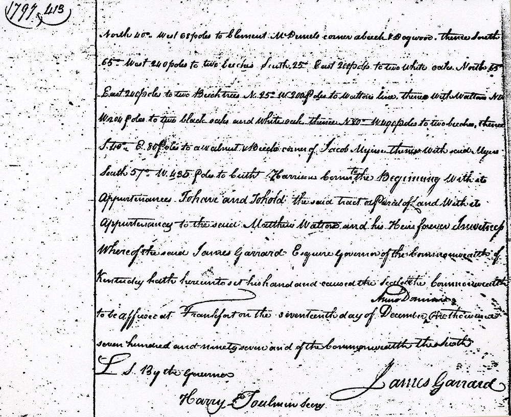
Beginning at Cuthbert Harrison's 5000 acre survey at his northwest corner at Spanish oak and hickory, thence with said Harrison South 52° East 140 poles to a corner of Abner Luce's at a sugar tree, thence with said line North 45° East 56 poles to two beeches, South 30° East 40 poles to a white oak, North 78° East 106 poles to a hickory and beech, North 20° East 80 poles to two white oaks, South 65° East 86 poles to two sugar trees, South 35° West 160 poles to a beech, South 35° East 45 poles to a black oak, North 85° East 116 poles to a dogwood and gum, South 65° East 66 poles to a white oak, North 45° East 100 poles to two white oaks, South 52° East 194 poles to an ash and white oak, South 45° West 250 poles to a black oak and hickory in Harrison's line, thence with Harrison's South 52° East 520 poles to Samuel Smith's survey at a white oak, thence with said Smith North 85° East 343 poles to a white oak and beech in Macher's line, a corner to said Smith, thence with Macher's North 16° East 85 poles to a white oak, thence with Macher North 80° East 100 poles to a black oak and white oak, thence with said Macher North 45° West 20 poles to a white oak and chestnut oak, thence North 45° East 228 1/2 poles to two white oaks and gum, South 45° East 140 poles to a white oak and gum in Macher's line, thence with Macher North 45° East 120 poles to said Macher's and Reeve's corner at a hickory and white oak, thence with Reeves North 80° East 210 poles to two white oaks in Lenham's line, thence with said Lenham North 130 poles to a white oak in Richard Morton's line, thence South 79° West 320 poles with said Morton's to a black oak and two white oaks, thence North 11° West 120 poles to Baley's corner three maples and dogwood, South 80° West 253 poles to two white oaks, thence North 10° West 200 poles to Walton's survey of 7880 acres, part of the same entry, thence with said survey to a beech, thence South 75° West 255 poles to two white oaks and dogwood, North 40° West 68 poles to Clement McDaniels' corner a beech and dogwood, thence South 65° West 240 poles to two two beeches, South 25° East 200 poles to two white oaks, North 65° East 240 poles to two beech trees, North 25° East 200 poles to Walton's line, thence with Walton's North 40° West 204 poles to two black oaks and white oak, thence North 80° West 490 poles to two beeches, thence South 40° East 80 poles to a walnut and beech corner of Jacob Myer's, thence with said Myers South 57° West 435 poles to Cuthbert Harrison's corner the beginning with its appurtenances.
To have and to hold the said tract or parcel of land with its appurtenances to the said Matthew Walton and his heirs forever. In witness whereof the said James Garrard Esquire, Governor of the Commonwealth of Kentucky, hath hereunto set his hand and caused the seal of the Commonwealth to be affixed at Frankfort on the 17th day of December, A.D. 1797, and of the Commonwealth the sixth. (signed) James Garrard
If you, the reader, have an interest in any particular part of our county history, and wish to contribute to this effort, use the form on our Contact Us page to send us your comments about this, or any Bullitt County History page. We welcome your comments and suggestions. If you feel that we have misspoken at any point, please feel free to point this out to us.
The Bullitt County History Museum, a service of the Bullitt County Genealogical Society, is located in the county courthouse at 300 South Buckman Street (Highway 61) in Shepherdsville, Kentucky. The museum, along with its research room, is open 10 a.m. to 4 p.m. Monday through Friday. Saturday appointments are available by calling 502-921-0161 during our regular weekday hours. Admission is free. The museum, as part of the Bullitt County Genealogical Society, is a 501(c)3 tax exempt organization and is classified as a 509(a)2 public charity. Contributions and bequests are deductible under section 2055, 2106, or 2522 of the Internal Revenue Code. Page last modified: 21 Apr 2026 . Page URL: bullittcountyhistory.org/bchistory/ok2079-walton.html