
On 23 Mar 1781, Benjamin Stansbury completed a 600 acre survey for Peter Shepherd of Baltimore, which was opposite a 900 acre tract he also surveyed for Shepherd. Both surveys lay alongside Salt River. Peter's son Adam would be the one to handle his father's dealings in Kentucky. He later sold 100 acres of this tract to Benjamin Stansbury on 25 Jul 1797
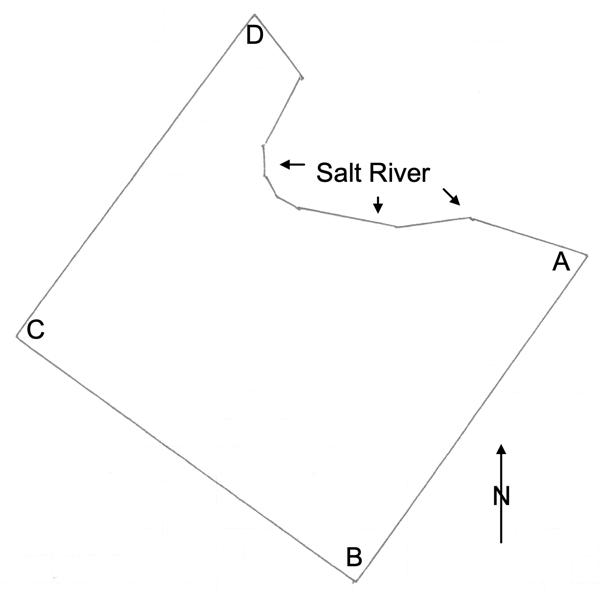
The drawing shown here has been oriented to due north, and the main corners of the tract are labeled.
Survey
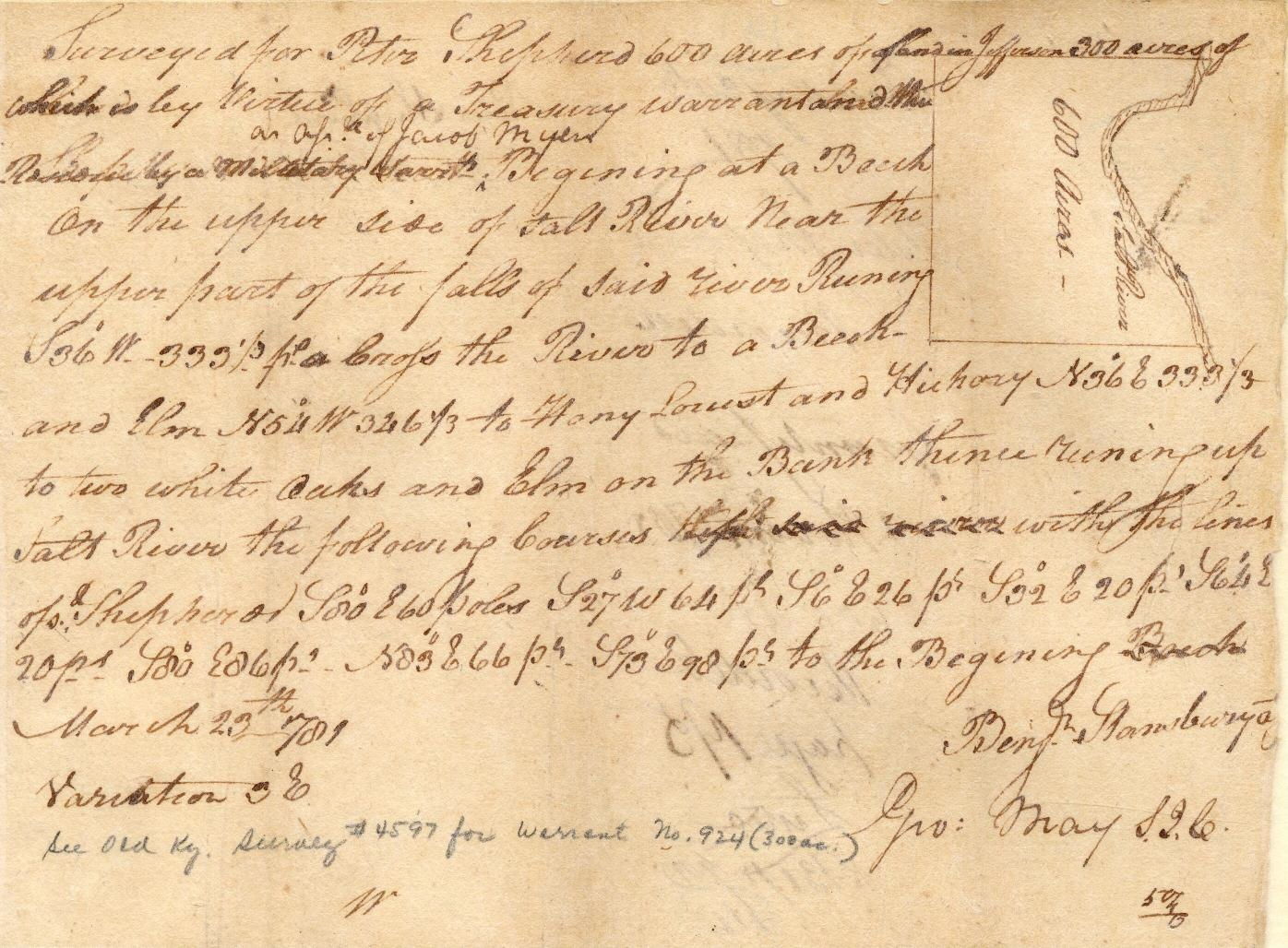
Surveyed for Peter Shepherd 600 acres of land in Jefferson, 300 acres of which is by virtue of a treasury warrant and the residue as an assignee of Jacob Myers. Beginning at [A] a beech on the upper side of Salt River near the upper parts of the Falls of said river, running S 36° W 333 1/3 poles across the river to [B] a beech and elm, N 54° W 346 1/3 poles to [C] a honey locust and hickory, N 36° E 333 1/3 poles to [D] two white oaks and elm on the bank, thence running up Salt River the following courses with the line of said Shepherd S 80° E 60 poles, S 27° W 64 poles, S 6° E 26 poles, S 32° E 20 poles, S 64° E 20 poles, S 80° E 86 poles, N 83° E 66 poles, S 73° E 98 poles to the beginning. March 23rd 1881. Benjamin Stansbury, surveyor.
Deed
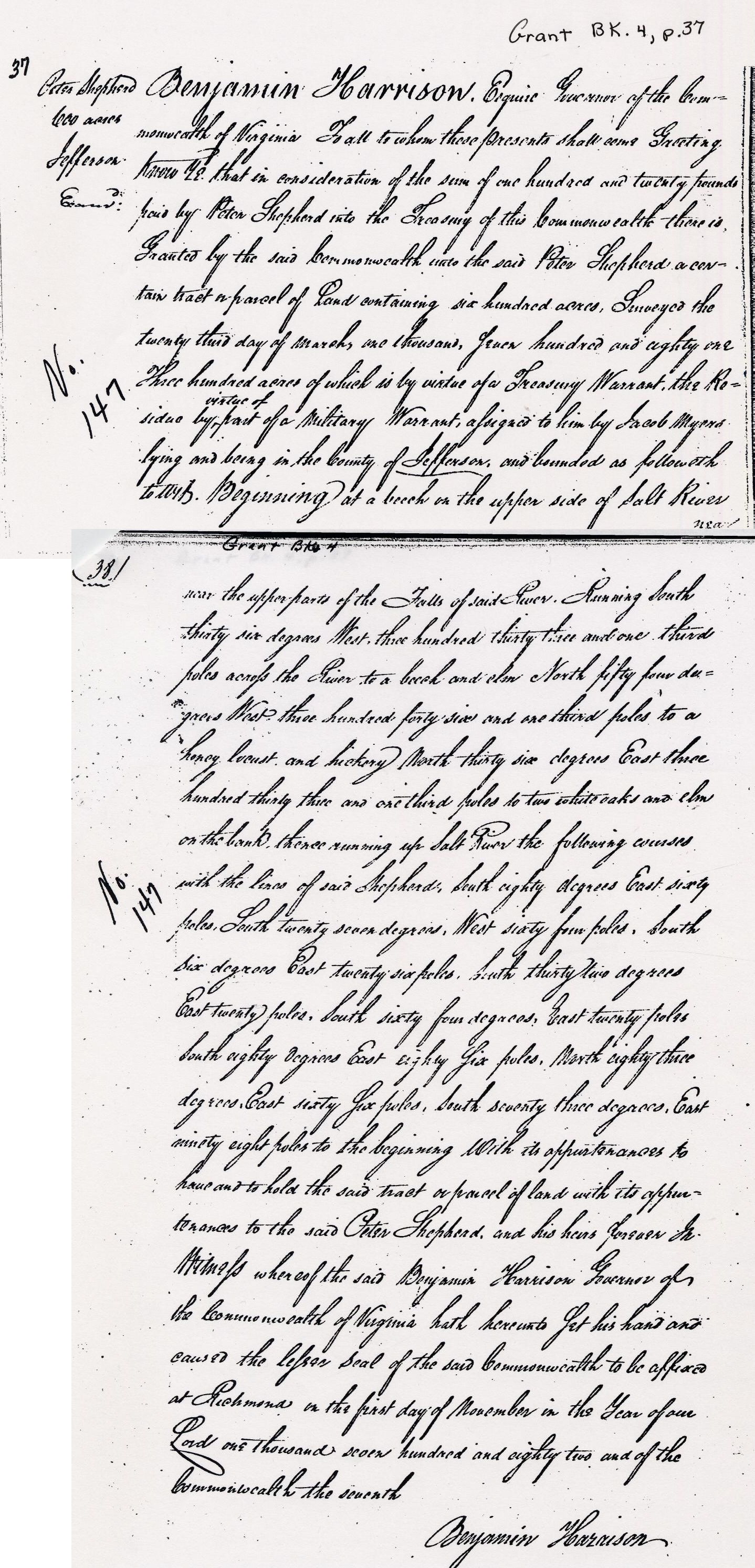
Grant Bk 4, p. 37
Peter Shepherd 600 Acres in Jefferson County
Benjamin Harrison Esquire Governor of the Commonwealth of Virginia To all to whom these presents shall come Greeting. Know ye that in consideration of the sum of one hundred and twenty pounds paid by Peter Shepherd into the treasury of this Commonwealth there is granted by the said Commonwealth unto the said Peter Shepherd a contain tract or parcel of land containing six hundred acres, Surveyed the twenty third day of March, one thousand, seven hundred and eighty one. Three hundred of which is by virtue of a Treasury Warrant, the residue by virtue of a military warrant, assigned to him by Jacob Myers, lying and being in the County of Jefferson, and bounded as followeth to wit. Beginning at a beech on the upper side of Salt River near the upper parts of the Falls of said river, running South thirty six degrees West three hundred thirty three and one third poles across the river to a beech and elm North fifty four degrees West three hundred forty six and one third poles to a honey locust and hickory North thirty six degrees East three hundred thirty three and one third poles to two white oaks and elm on the bank thence running up Salt River the following courses with the line of said Shepherd South eighty degrees East sixty poles South twenty seven degrees West sixty four poles South six degrees East twenty six poles South thirty two degrees East twenty poles South sixty four degrees East twenty poles South eighty degrees East eighty six poles North eighty three degrees East sixty six poles South seventy three degrees East ninety eight poles to the beginning with its appurtenances to have to to hold the said tract or parcel of land with its appurtenances to the said Peter Shepherd and his heirs forever. In witness whereof the said Benjamin Harrison Governor of the Commonwealth of Virginia hath hereunto set his hand and caused the seal of the said Commonwealth to be affixed at Richmond on the first day of November in the year of our Lord one thousand seven hundred and eighty two and of the Commonwealth the seventh.
Benjamin Harrison
Peter Shepherd's 600 acre tract is marked as [B] on the drawing below.

If you, the reader, have an interest in any particular part of our county history, and wish to contribute to this effort, use the form on our Contact Us page to send us your comments about this, or any Bullitt County History page. We welcome your comments and suggestions. If you feel that we have misspoken at any point, please feel free to point this out to us.
The Bullitt County History Museum, a service of the Bullitt County Genealogical Society, is located in the county courthouse at 300 South Buckman Street (Highway 61) in Shepherdsville, Kentucky. The museum, along with its research room, is open 10 a.m. to 4 p.m. Monday through Friday. Saturday appointments are available by calling 502-921-0161 during our regular weekday hours. Admission is free. The museum, as part of the Bullitt County Genealogical Society, is a 501(c)3 tax exempt organization and is classified as a 509(a)2 public charity. Contributions and bequests are deductible under section 2055, 2106, or 2522 of the Internal Revenue Code. Page last modified: 11 May 2026 . Page URL: bullittcountyhistory.org/bchistory/petershepherd600.html