
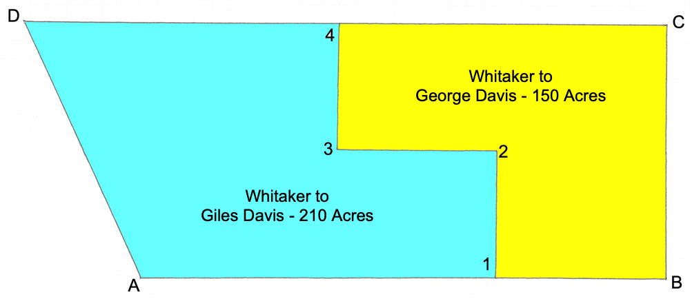
Isaac Cox surveyed this 360 acre tract on Cedar Creek for John Whitaker on 20 Jan 1786, who received the deed for it on 18 Aug 1788. John, and his wife Mary, sold 210 acres of it to Giles Davis on 20 Aug 1796. They then sold the remaining 150 acres to George Davis the same day. The drawing below shows the initial survey as it was divided between the two men.
Survey
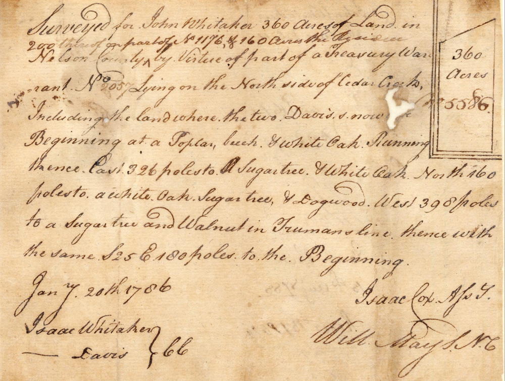
Surveyed for John Whitaker 360 acres of land in Nelson County, 200 thereof on part of No 1176 & 160 acres the residue by virtue of part of a treasury warrant No. 2057, lying on the north side of Cedar Creek including the land where the two Davis's now live. Beginning at [A] a poplar, beech & white oak, running thence East 326 poles to [B] a sugar tree & white oak, North 160 poles to [C] a white oak, sugar tree & dogwood, West 398 poles to [D] a sugar tree and walnut in Truman's line, thence with the same S 25 E 180 poles to the beginning. January 20th 1786. Isaac Cox, surveyor. Chain Carriers: Isaac Whitaker, __ Davis.
Deed
Virginia Grant Book 16, pages 63-64
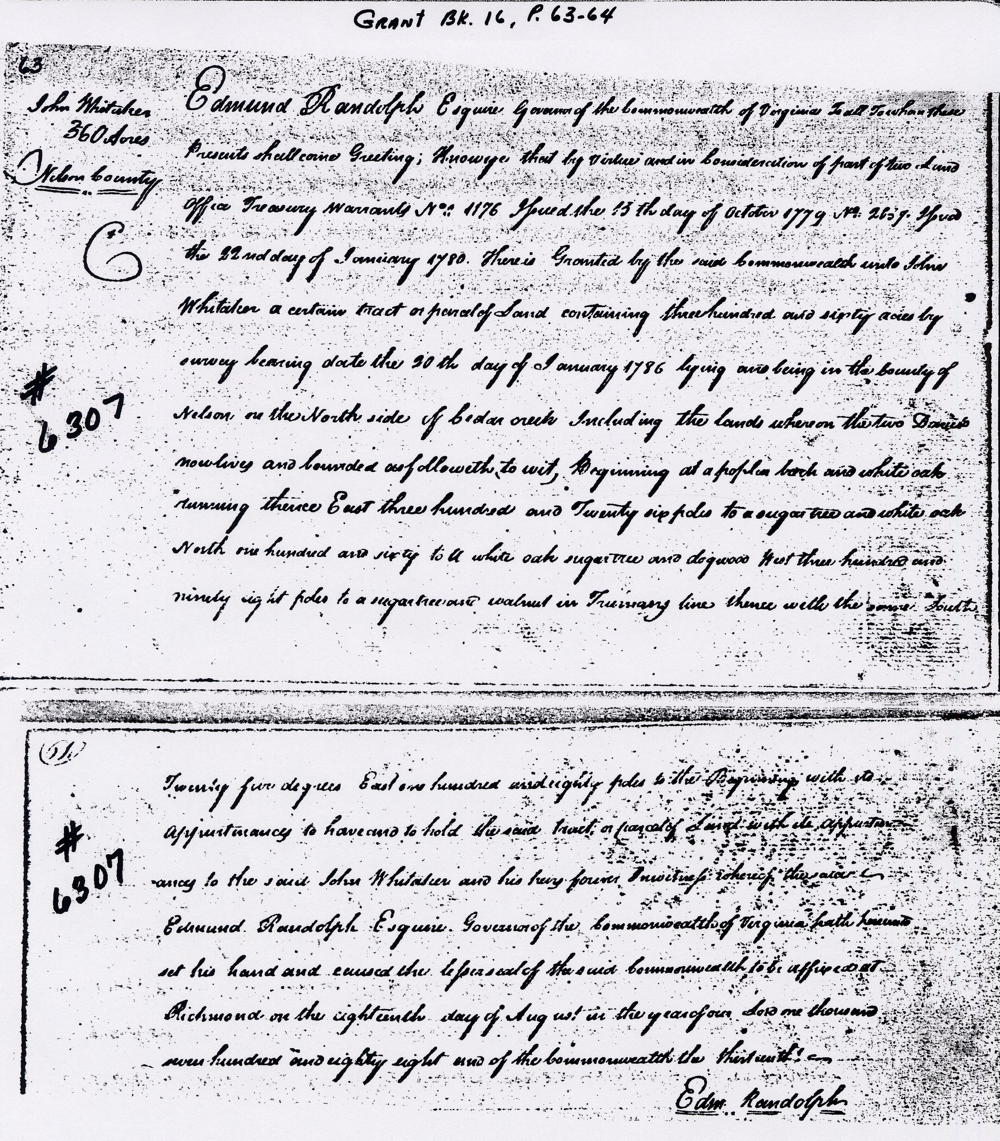
Edmund Randolph Esquire, Governor of the Commonwealth of Virginia, to all to whom these presents shall come, greeting. Know ye that by virtue and in consideration of part of two land office treasury warrants No. 1176, issued the 13th day of October 1779, No. 2057, issued the 22nd day of January 1780, there is granted by the said Commonwealth unto John Whitaker a certain tract or a parcel of land containing 360 acres by survey bearing date the 20th day of January 1786, lying and being in the county of Nelson on the north side of Cedar Creek including the lands where the two Davis's now live, and bounded as followeth, to wit. Beginning at a poplar, beech and white oak running thence East 326 poles to a sugar tree and white oak, North 160 [poles] to a white oak, sugar tree and dogwood, West 398 poles to a sugar tree, and walnut in Truman's line, thence with the same South 25° East 180 poles to the beginning with its appurtenances to have and to hold the said tract or parcel of land with its appurtenances to the said John Whitaker and his heirs forever. In witness whereof the said Edmund Randolph Esquire, Governor of the Commonwealth of Virginia, hath hereunto set his hand and caused the lesser seal of the said Commonwealth to be affixed at Richmond on the 18th day of August in the year of our Lord 1788 and of the Commonwealth the 13th. (signed) Edmund Randolph
If you, the reader, have an interest in any particular part of our county history, and wish to contribute to this effort, use the form on our Contact Us page to send us your comments about this, or any Bullitt County History page. We welcome your comments and suggestions. If you feel that we have misspoken at any point, please feel free to point this out to us.
The Bullitt County History Museum, a service of the Bullitt County Genealogical Society, is located in the county courthouse at 300 South Buckman Street (Highway 61) in Shepherdsville, Kentucky. The museum, along with its research room, is open 10 a.m. to 4 p.m. Monday through Friday. Saturday appointments are available by calling 502-921-0161 during our regular weekday hours. Admission is free. The museum, as part of the Bullitt County Genealogical Society, is a 501(c)3 tax exempt organization and is classified as a 509(a)2 public charity. Contributions and bequests are deductible under section 2055, 2106, or 2522 of the Internal Revenue Code. Page last modified: 04 Sep 2025 . Page URL: bullittcountyhistory.org/bchistory/whitaker6307.html