
Thomas Whitledge surveyed a 200 acre tract for William Owens on 7 May 1784 at the junction of Salt River and Cedar Creek. A deed to the tract was issued to Owens on 7 Jul 1786. Both survey and deed are shown below, together with their transcriptions.
Survey
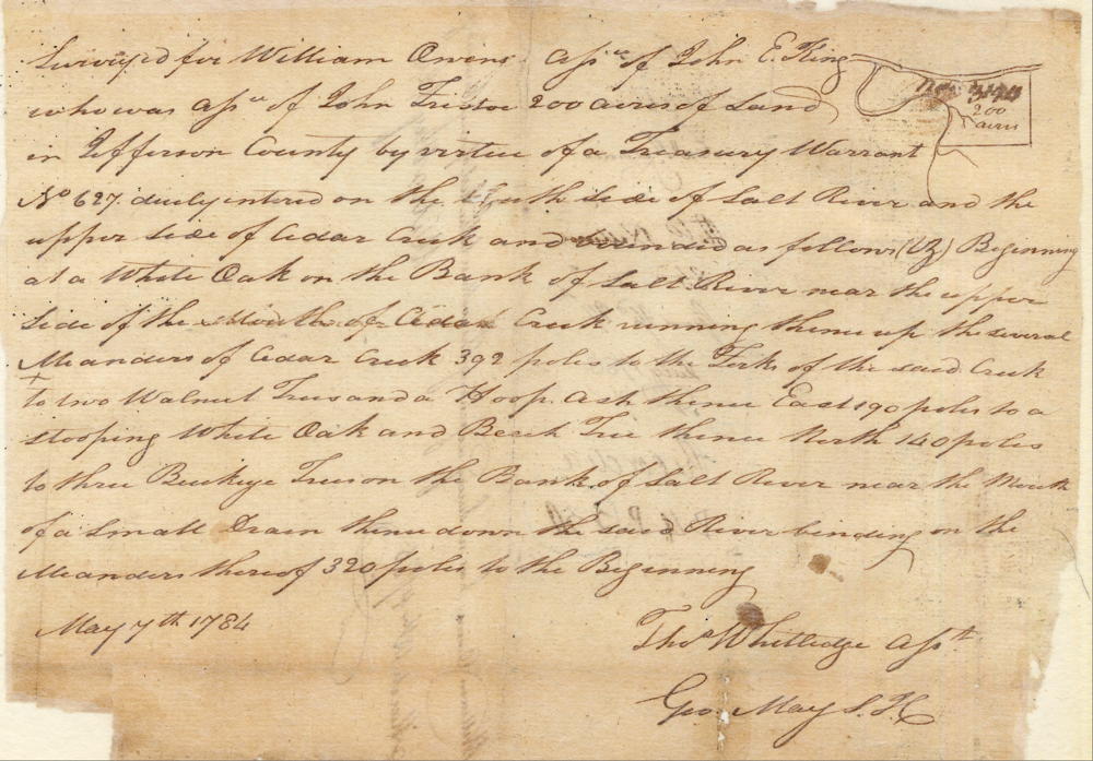
Surveyed for William Owens assignee of John E. King who was assignee of John Fristoe 200 acres of land in Jefferson County by virtue of a treasury warrant No. 627 duly entered on the south side of Salt River and the upper side of Cedar Creek and bounded as follows (viz) Beginning at a white oak on the bank of Salt River near the upper side of the mouth of Cedar Creek, running thence up the several meanders of Cedar Creek 392 poles to the fork of the said creek to two walnut trees and a hoop ash, thence East 190 poles to a stooping white oak and beech tree, thence North 140 poles to three buckeye trees on the bank of Salt River near the mouth of a small drain, thence down the said river binding on the meanders thereof 320 poles to the Beginning. May 7th 1784. Thomas Whitledge, Assistant Surveyor
Deed
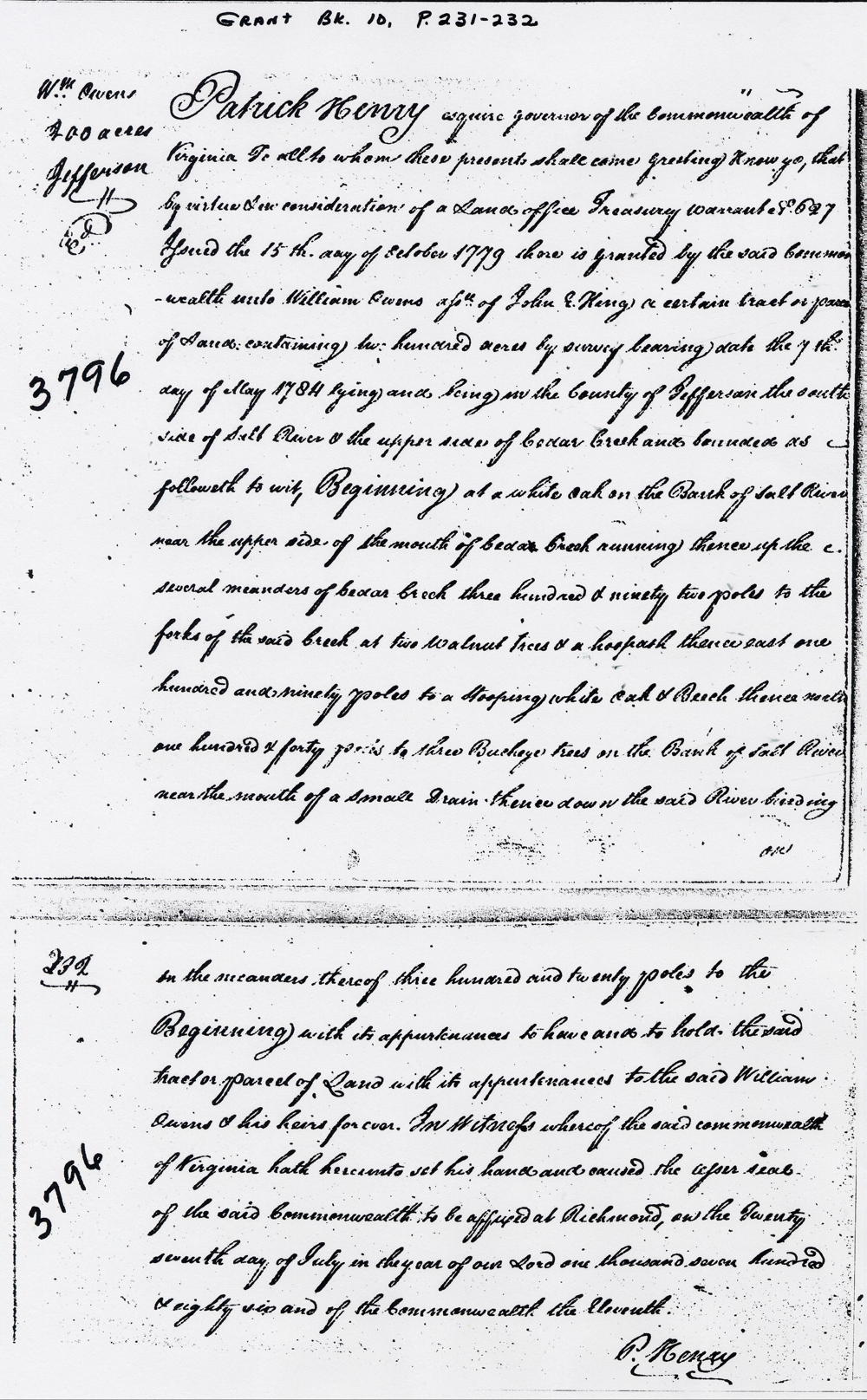
Virginia Grant Book 10, pp 231-2
Patrick Henry Esquire, Governor of the Commonwealth of Virginia to all to whom these presents shall come, greeting. Know ye that by virtue and in consideration of a land office treasury warrant No. 627 issued the 15th day of October 1779 there is granted by the said Commonwealth unto William Owens, assignee of John E. King, a certain tract or parcel of land containing two hundred acres by survey bearing date the 7th day of May 1784 lying and being in the county of Jefferson on the south side of Salt River & the upper side of Cedar Creek and bounded as followeth, to wit. Beginning at a white oak on the bank of Salt River near the upper side of the mouth of Cedar Creek, running thence up the several meanders of Cedar Creek three hundred and ninety two poles to the forks of the said creek at two walnut trees & a hoop ash, thence East one hundred and ninety poles to a stooping white oak & beech, thence North one hundred & forty poles to three buckeye trees on the bank of Salt River near the mouth of a small drain, thence down the said river binding on the meanders thereof three hundred and twenty poless to the Beginning with it appurtenances to have and to hold the siad tract or parcel of land with its appurtenances to the said William Owens & his heirs forever. In witness whereof the said Commonwealth of Virginia hath hereunto set his hand and caused the lesser seal of the said Commonwealth to be affixed at Richmond on the twenty seventh day of July in the year of our Lord one thousand seven hundred & eighty six and of the Commonwealth the eleventh. (signed) P. Henry
If you, the reader, have an interest in any particular part of our county history, and wish to contribute to this effort, use the form on our Contact Us page to send us your comments about this, or any Bullitt County History page. We welcome your comments and suggestions. If you feel that we have misspoken at any point, please feel free to point this out to us.
The Bullitt County History Museum, a service of the Bullitt County Genealogical Society, is located in the county courthouse at 300 South Buckman Street (Highway 61) in Shepherdsville, Kentucky. The museum, along with its research room, is open 10 a.m. to 4 p.m. Monday through Friday. Saturday appointments are available by calling 502-921-0161 during our regular weekday hours. Admission is free. The museum, as part of the Bullitt County Genealogical Society, is a 501(c)3 tax exempt organization and is classified as a 509(a)2 public charity. Contributions and bequests are deductible under section 2055, 2106, or 2522 of the Internal Revenue Code. Page last modified: 12 Sep 2024 . Page URL: bullittcountyhistory.org/bchistory/william-owens200.html