
In December 1790, Benjamin Stansbury gained title to an oddly shaped tract of land that lay between the William Christian 1000 acre tract that included Bullitt's Lick and the two Peter Shepherd tracts of 900 and 600 acres that included the future site of Shepherdsville. Here is an image of the deed.
The tract had been surveyed for Charles Boone on 18 Dec 1788 by James F. Moore, and Boone had apparently placed Adam Shepherd in charge of selling it.
Survey
Surveyed for Charles Boone 456 acres of land in Jefferson & Nelson Countys, the greater part thereof in Jefferson County, part of an entry of 500 acres made on part of a Treasury warrant No. 4866, and bounded as follows. Viz, Beginning at a Honey Locust & Hickory, corner to Shepherd's 600 acre survey and running thence N 36° E 156 poles to an Elm, Beech & Sweet Gum standing on the bank of Salt River, thence down the same N 70 poles, N 10° E 40 poles, thence across the river N 30° E 20 poles to a White Oak & Elm standing on the bank of the river & corner to Shepherd's 900 acre survey, and with a line thereof N 37° W 177 poles to his corner two Hickories ... N 10° W 350 poles to a Red Oak & two Pines standing on the side of a ridge at the foot of the knobs, S 80° W 330 poles to two White Oaks on the side of a hill near the south fork of Lick Run & on the north side of the same, S 10° E 168 poles to a stake in a line of William Christian's military survey that includes Bullitt's Lick, and with the same N 55° E 190 poles to two Walnuts and a Honey Locust corner to said Christian and with another of his lines S 39° E 460 poles to a White Oak standing on the river bank marked W C, thence S 30° W 20 poles crossing Salt River and down the same binding thereon the several courses thereof W 20 poles, S 55° W 84 poles, S 140 poles, S 6° W 57 poles to three Honey Locusts & a Buckeye, N 70° E 6 poles to the beginning. Surveyed Dec 18th, 1788.
James F. Moore

Here is the back side of that survey showing its transfer to Stansbury.
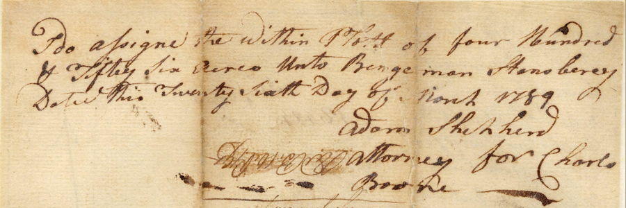
Deed
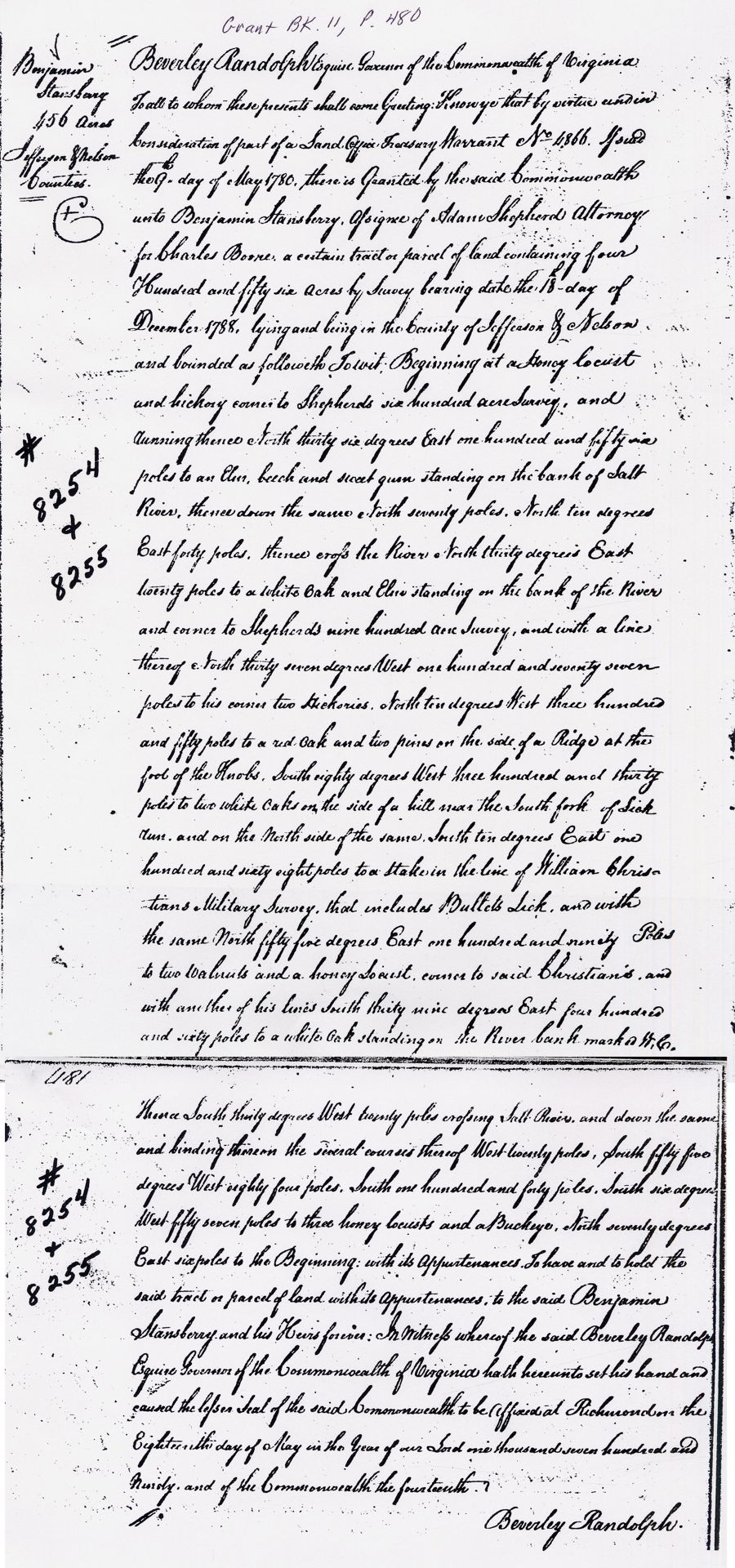
Virginia Grant Book 11, page 480
Beverly Randolph Esquire, Governor of the Commonwealth of Virginia, to all to whom these presents shall come, Greeting. Knew ye that by virtue and in consideration of part of a Land Office Treasury Warrant No. 4866 issued the 9th day of May 1780, there is granted by the said Commonwealth unto Benjamin Stansberry, assignee of Adam Shepherd, attorney for Charles Boone, a certain tract or parcel of land containing four hundred and fifty six acres by survey bearing date the 18th day of December 1788, lying and being in the County of Jefferson & Nelson and bounded as followeth To Wit: Beginning at a Honey locust and hickory corner to Shepherd's six hundred acre survey, and running thence North thirty six degrees East one hundred and fifty six poles to an Elm, beech and sweet gum standing on the bank of Salt River, thence down the same North seventy poles, North ten degrees East forty poles, thence cross the River North thirty degrees East twenty poles to a white oak and elm standing on the bank of the river and corner to Shepherd's nine hundred acre survey, and with a line thereof North thirty seven degrees West one hundred and seventy seven poles to his corner two hickories, North ten degrees West three hundred and fifty poles to a red oak and two pines on the side of a ridge at the foot of the Knobs, South eighty degrees West three hundred and thirty poles to two white oaks on the side of a hill near the South fork of Lick run, and on the north side of the same, South ten degrees East one hundred and sixty eight poles to a stake in the line of William Christian's military survey that includes Bullets Lick and with the same North fifty five degrees East one hundred and ninety poles to two walnuts and a honey locust corner to said Christian's and with another of his lines South thirty nine degrees East four hundred and sixty poles to a while oak standing on the river bank marked W. C., thence South thirty degrees West twenty poles crossing Salt River and down the same and binding thereon the several courses thereof West twenty poles, South fifty five degrees West eighty four poles, South one hundred and forty poles, South six degrees West fifty seven poles to three honey locusts and a Buckeye, North seventy degrees East six poles to the Beginning, with it appurtenances, to have and to hold the said tract or parcel of land with it appurtenances to the said Benjamin Stansberry and his Heirs forever. In witness whereof the said Beverley Randolph Esquire, Governor of the Commonwealth of Virginia hath hereunto set his hand and caused the lesser seal of the said Commonwealth to be affixed at Richmond on the Eighteenth day of May in the Year of our Lord one thousand seven hundred and ninety, and the Commonwealth the fourteenth.
(signed) Beverley Randolph
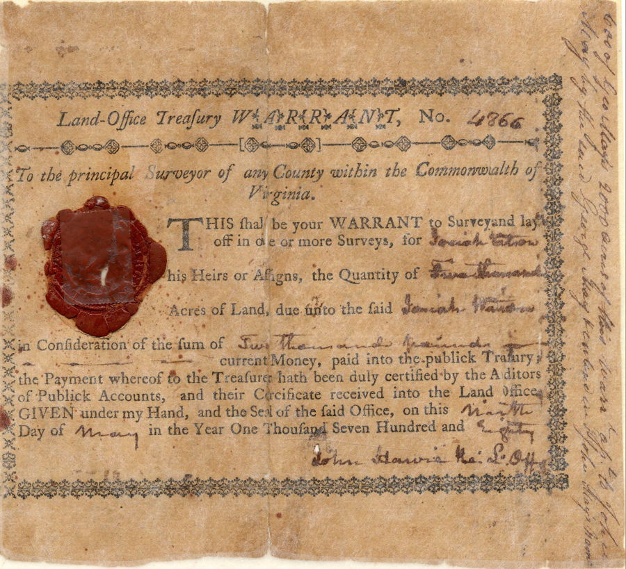
An interesting aspect of this deed and survey is how the treasury warrant supporting it changed hands and was divided up among several folks. Images of the front and back of this warrant are shown below, and you are welcome to try to decipher it.

If you, the reader, have an interest in any particular part of our county history, and wish to contribute to this effort, use the form on our Contact Us page to send us your comments about this, or any Bullitt County History page. We welcome your comments and suggestions. If you feel that we have misspoken at any point, please feel free to point this out to us.
The Bullitt County History Museum, a service of the Bullitt County Genealogical Society, is located in the county courthouse at 300 South Buckman Street (Highway 61) in Shepherdsville, Kentucky. The museum, along with its research room, is open 10 a.m. to 4 p.m. Monday through Friday. Saturday appointments are available by calling 502-921-0161 during our regular weekday hours. Admission is free. The museum, as part of the Bullitt County Genealogical Society, is a 501(c)3 tax exempt organization and is classified as a 509(a)2 public charity. Contributions and bequests are deductible under section 2055, 2106, or 2522 of the Internal Revenue Code. Page last modified: 12 Apr 2026 . Page URL: bullittcountyhistory.org/bchistory/murder/boone-stansbury.html