
On 25 Oct 1792, Alexander Breckinridge surveyed 820 acres of land in what would later become northern Bullitt County for George Slaughter. On the 19 Feb 1800, Slaughter signed the survey over to Joseph Brooks who obtained a deed to the land on 8 Aug 1802. This land appears to lay to the west of Gabriel Jones' 2500 acre tract that James Shanks included on his 1811 plat of the area; and to the east of an adjoining tract of 680 acres that Breckinridge had surveyed for Slaughter the previous day.
Survey
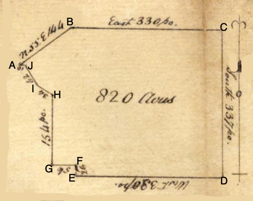
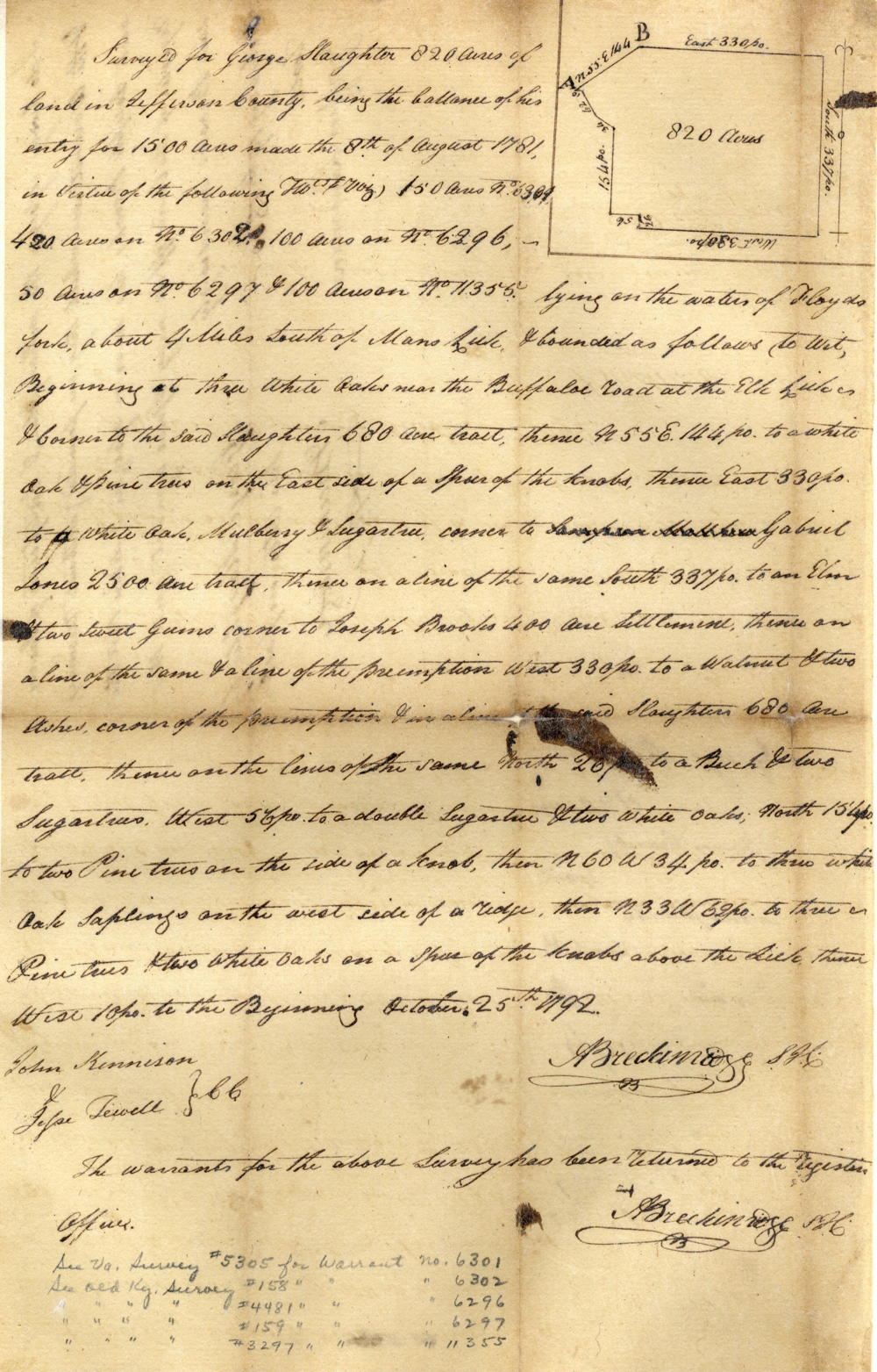
Surveyed for George Slaughter 820 acres of land in Jefferson County, being the balance of his entry for 1500 acres made the 8th of August 1781, in virtue of the following treasury warrants (viz) 150 acres No. 6301, 420 acres on No. 6302, 100 acres on No. 6296, 50 acres on No. 6297, & 100 acres on No. 11355 lying on the waters of Floyd's Fork, about 4 miles south of Mann's Lick & bounded as follows, to wit. Beginning at [A] three white oaks near the buffalo road at the Elk lick and corner to the said Slaughter's 680 acre tract, thence N 55° E 144 poles to [B] a white oak and pine trees on the east side of the spur of the knob, thence East 330 poles to [C] a white oak, mulberry & sugar tree corner to Gabriel Jones' 2500 acre tract, thence on a line of the same, South 337 poles to [D] an elm and two sweet gums corner to Joseph Brooks' 400 acre settlement, thence on a line of the same and a line of the preemption West 330 poles to [E] a walnut and two ashes corner of the preemption and in a line of the said Slaughter's 680 acre tract, thence on the line of the same, North 26 poles to [F] a beech and two sugar trees, West 56 poles to [G] a double sugar tree and two white oaks, North 154 poles to [H] two pine trees on the side of a knob, thence N 60° W 34 poles to [I] three wite oak saplings on the west side of a ridge, then N 33° W 62 poles to [J] three pine trees and two white oaks on a spur of the knobs above the lick, thence West 10 poles to the beginning. October 25th 1792. Alexander Breckinridge, surveyor. John Kennison & Jesse Jewell, chain carriers.
Deed
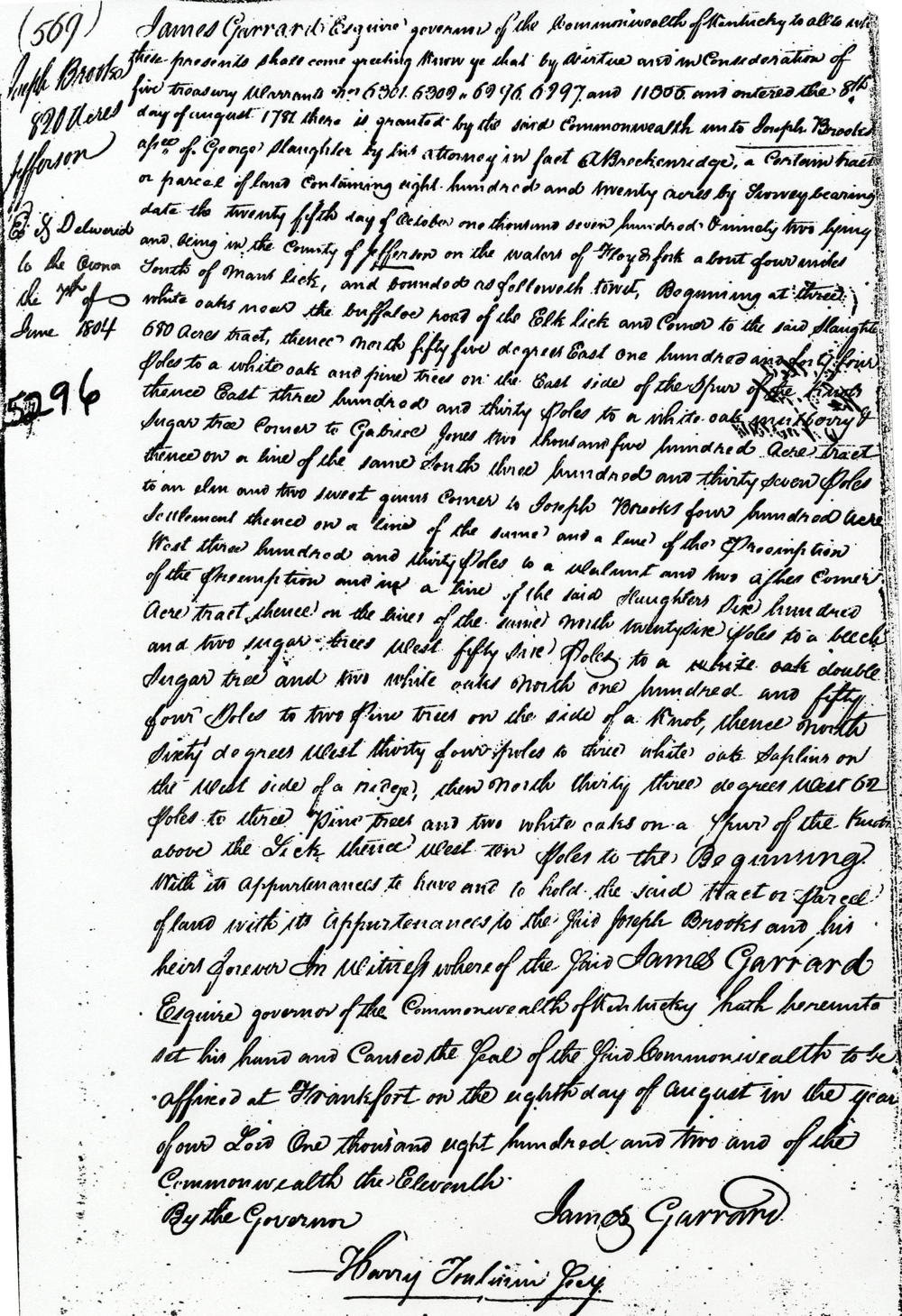
James Garrard Esquire, governor of the Commonwealth of Kentucky, to all to whom these presents shall come, greeting. Know ye that by virtue and in consideration of five treasury warrants No.6301, 6302, 6296, 6297, and 11355 and entered the 8th day of August 1781, there is granted by the said Commonwealth unto Joseph Brooks, assignee of George Slaughter by his attorney in fact A. Breckinridge a certain tract or parcel of land containing 820 acres by survey bearing date the 25th day of October 1792, lying and being in the county of Jefferson on the waters of Floyd's Fork, about four miles south of Mann's Lick, and bounded as followeth to wit. Beginning at three white oaks near the buffalo road of the Elk lick and corner to the said Slaughter's 680 acre tract, thence North 55° East 144 poles to a white oak and pine trees on the east side of the spur of the knob, thence East 330 poles to a white oak, mulberry & sugar tree corner to Gabriel Jones 2500 acre tract, thence on a line of the same, South 337 poles to an elm and two sweet gums corner to Joseph Brooks' 400 acre settlement, thence on a line of the same and a line of the preemption West 330 poles to a walnut and two ashes corner of the preemption and in a line of the said Slaughter's 680 acre tract, thence on the line of the same, North 26 poles to a beech and two sugar trees, West 56 poles to a double sugar tree and two white oaks, North 154 poles to two pine trees on the side of a knob, thence North 60° West 34 poles to three wite oak saplings on the west side of a ridge, then North 33° West 62 poles to three pine trees and two white oaks on a spur of the knobs above the lick, thence West 10 poles to the beginning with its appurtenances to have and to hold the said tract or parcel of land with its appurtenances to the said Joseph Brooks and his heirs forever. In witness whereof the said James Garrard Esquire, governor of the Commonwealth of Kentucky, hath hereunto set his hand and caused the seal of the said Commonwealth to be affixed at Frankfort on the 8th day of August in the year of our Lord 1802, and of the Commonwealth the 11th. (signed) James Garrard
If you, the reader, have an interest in any particular part of our county history, and wish to contribute to this effort, use the form on our Contact Us page to send us your comments about this, or any Bullitt County History page. We welcome your comments and suggestions. If you feel that we have misspoken at any point, please feel free to point this out to us.
The Bullitt County History Museum, a service of the Bullitt County Genealogical Society, is located in the county courthouse at 300 South Buckman Street (Highway 61) in Shepherdsville, Kentucky. The museum, along with its research room, is open 10 a.m. to 4 p.m. Monday through Friday. Saturday appointments are available by calling 502-921-0161 during our regular weekday hours. Admission is free. The museum, as part of the Bullitt County Genealogical Society, is a 501(c)3 tax exempt organization and is classified as a 509(a)2 public charity. Contributions and bequests are deductible under section 2055, 2106, or 2522 of the Internal Revenue Code. Page last modified: 21 Apr 2026 . Page URL: bullittcountyhistory.org/bchistory/ok5246-brooks.html