
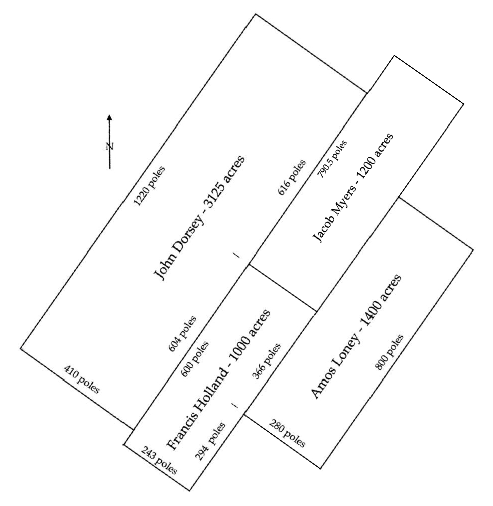
Jacob Myers claimed 1200 acres that lay north of the Salt River between the Rolling Fork and Mill Creek in what is today Fort Knox. According to his survey, this tract lay northeast of Francis Holland's 1000 acres, and between Amos Loney's 1400 acres and John Dorsey's 3125 acre survey.
At some point John Logan obtained this land and sold it to Samuel Goldsmith in 1821.
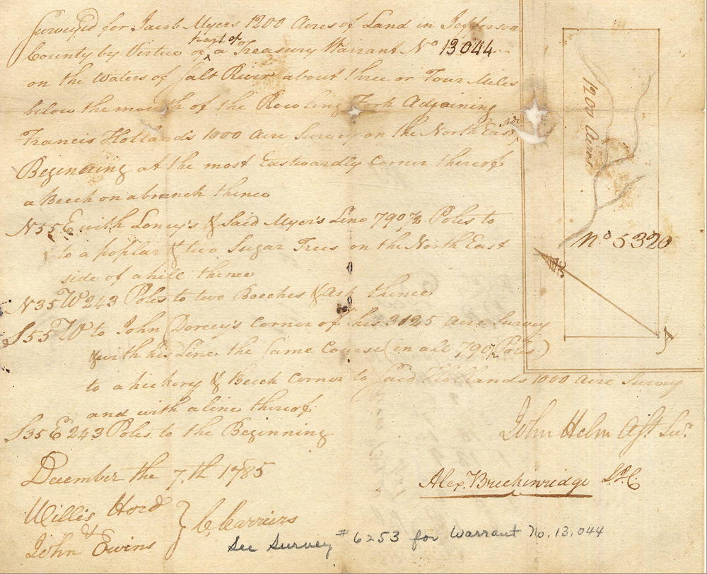
Survey
Surveyed for Jacob Myers 1200 acres of land in Jefferson County by virtue of part of a treasury warrant No. 13044 on th waters of Salt River about three or four miles below the mouth of the Rolling Fork, adjoining Francis Holland's 1000 acre survey on the northeast side. Beginning at the most eastwardly corner thereof, a beech on a branch, thence North 55° East with Loney's and said Myers' line 790 1/2 poles to a poplar and two sugar trees on the northeast side of a hill, thence North 35° West 243 poles to two beeches and ash, thence South 55° West to John Dorsey's corner of his 3125 acre survey and with his line the same course (in all 790 1/2 poles) to a hickory and beech, corner to said Holland's 1000 acres survey and with a line thereof South 35° East 243 poles to the beginning. John Helm, surveyor. December the 7th 1785.
Deed
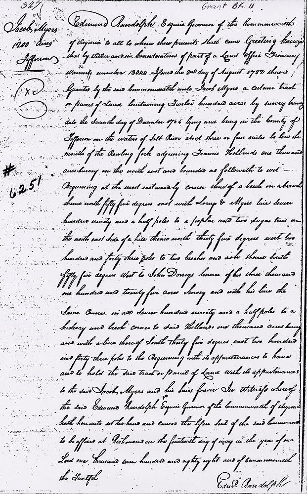
Virginia Grant Book 11, Page 327
Edmund Randolph Esquire, Governor of the Commonwealth of Virginia, to all to whom these presents shall come, greeting. Know ye that by virtue and in consideration of part of a land office treasury warrant number 13044, issued the 2nd day of August 1782, there is granted by the said Commonwealth unto Jacob Myers a certain tract or parcel of land containing 1200 acres by survey bearing date the seventh day of December 1785, lying and being in the County of Jefferson on the waters of Salt River about three or four miles below the mouth of the Rolling Fork, adjoining Francis Holland's 1000 acre survey on the northeast and bounded as followeth, to wit.
Beginning at the most eastwardly corner thereof, a beech on a branch, thence North 55° East with Loney's and Myers' line 790 1/2 poles to a poplar and two sugar trees on the northeast side of a hill, thence North 35° West 243 poles to two beeches and ash, thence South 55° West to John Dorsey's corner of 3125 acre survey and with his line the same course in all 790 1/2 poles to a hickory and beech, corner to said Holland's 1000 acres survey and with a line thereof South 35° East 243 poles to the beginning with its appurtenances, to have and to hold the said tract or parcel of land with its appurtenances to the said Jacob Myers and his heirs forever.
In witness whereof the said Edmund Randolph Esquire, Governor of the Commonwealth of Virginia, hath hereunto set his hand and caused the lesser seal of the said Commonwealth to be affixed at Richmond on the 14th day of May in the year of our Lord 1788, and of the Commonwealth the 12th. (signed) Edmund Randolph
If you, the reader, have an interest in any particular part of our county history, and wish to contribute to this effort, use the form on our Contact Us page to send us your comments about this, or any Bullitt County History page. We welcome your comments and suggestions. If you feel that we have misspoken at any point, please feel free to point this out to us.
The Bullitt County History Museum, a service of the Bullitt County Genealogical Society, is located in the county courthouse at 300 South Buckman Street (Highway 61) in Shepherdsville, Kentucky. The museum, along with its research room, is open 10 a.m. to 4 p.m. Monday through Friday. Saturday appointments are available by calling 502-921-0161 during our regular weekday hours. Admission is free. The museum, as part of the Bullitt County Genealogical Society, is a 501(c)3 tax exempt organization and is classified as a 509(a)2 public charity. Contributions and bequests are deductible under section 2055, 2106, or 2522 of the Internal Revenue Code. Page last modified: 21 Apr 2026 . Page URL: bullittcountyhistory.org/bchistory/6251-myers.html